Allende, Coahuila facts for kids
Quick facts for kids
Allende, Coahuila
|
|
|---|---|
 |
|
| Nickname(s):
Coah
|
|
| Country | |
| State | Coahuila |
| Municipality | Allende |
| Founded | 16 March 1826 |
| Area | |
| • Municipality | 198.70 km2 (76.72 sq mi) |
| Elevation | 380 m (1,250 ft) |
| Population
(2000)
|
|
| • Metro | 20,153 (Municipality) |
| Time zone | UTC-6 (Central (US Central)) |
| • Summer (DST) | UTC-5 (Central) |
| Postal code |
26531
|
| Area code(s) | 862 |
| Website | www.allendecoahuila.gob.mx |
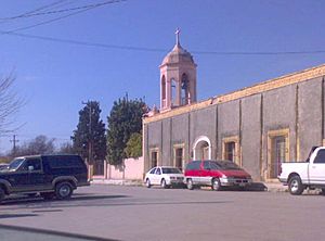
Allende is a city in the Mexican state of Coahuila. It's like the main office for the area around it, called the Allende Municipality.
History of Allende
The city is named after Ignacio Allende. He was a brave hero during Mexico's fight for independence. Before 1832, the town was known as San Juan de Mata.
A local hero from Allende is Arnulfo González. People sing "corridos" (story-songs) about him. Famous singers like Vicente Fernández have sung his corrido.
Where is Allende?
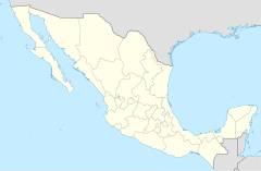
Allende is located at about 28 degrees north and 100 degrees west. It sits about 380 meters (1,247 feet) above sea level.
The city is right on Federal Highway 57. The state capital, Saltillo, is about 390 kilometers (242 miles) to the south. The border crossing at Piedras Negras, Coahuila is about 55 kilometers (34 miles) north. This city is across the Río Bravo del Norte from Eagle Pass, Texas in the United States.
Allende also has a railway line. This railway connects Saltillo to another border city, Ciudad Acuña. Ciudad Acuña is across the river from Del Rio, Texas.
Allende Municipality Facts
The Allende municipality covers an area of about 198.70 square kilometers (76.72 square miles). In the year 2000, about 20,153 people lived there.
The town has a special annual festival. It's called the fiesta patronal and happens every year on August 29.
Besides the main city of Allende, there are two other small towns in the municipality. These are Río Bravo and Chamucero.
See also
 In Spanish: Allende (Coahuila) para niños


