Almogía facts for kids
Quick facts for kids
Almogía
|
||
|---|---|---|
 |
||
|
||

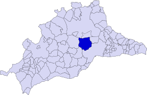
Municipal location in the Province of Málaga
|
||
| Sovereign state | ||
| Autonomous community | ||
| Province | ||
| Comarca | Málaga-Costa del Sol | |
| Area | ||
| • Total | 164 km2 (63 sq mi) | |
| Elevation | 357 m (1,171 ft) | |
| Population | ||
| • Total | 3,770 | |
| • Density | 22.99/km2 (59.54/sq mi) | |
| Demonym(s) | Almogiense | |
| Time zone | UTC+1 (CET) | |
| • Summer (DST) | UTC+2 (CEST) | |
| Postal code |
29150
|
|
| Website | www.almogia.es | |
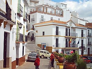
Almogía is a small town and a municipality in southern Spain. It is located in the province of Málaga. This area is part of the Andalusia region.
Almogía is about 25 kilometers (15 miles) away from the city of Málaga. Around 3,770 people live there. The main jobs in Almogía involve growing almonds and olives.
The town sits in the Montes de Málaga hills. Its highest point is Santi Petri, which is 794 meters (2,605 feet) tall. Important rivers and streams here are the River Campanillas and the Arroyos de Cauche and de los Olivos.
See also
 In Spanish: Almogía para niños
Black History Month on Kiddle
African-American activists you should know
 | Audre Lorde |
 | John Berry Meachum |
 | Ferdinand Lee Barnett |

All content from Kiddle encyclopedia articles (including the article images and facts) can be freely used under Attribution-ShareAlike license, unless stated otherwise. Cite this article:
Almogía Facts for Kids. Kiddle Encyclopedia.


