Alsek Glacier facts for kids
Quick facts for kids Alsek Glacier |
|
|---|---|

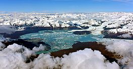
Alsek Lake on Glacier edge.
|
|
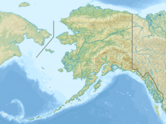
| Coordinates | 59°12′05″N 138°02′49″W / 59.20139°N 138.04694°W |
| Length | 24-kilometer (15 mi) |
| Highest elevation | 1033 ft |
The Alsek Glacier is a huge river of ice, about 24-kilometer (15 mi) long. You can find it in Glacier Bay National Park in the part of Alaska (USA) known as the Panhandle. The Panhandle is a long, narrow strip of land in the southeastern part of the state.
The name Alsek comes from the Tlingit people, who are a Native American group from the Pacific Northwest. The name might mean "place where people rest." An officer from the U.S. Navy, Lieutenant Commander Moser, officially named the glacier in 1901. He was in charge of a ship called the USS Albatross, which belonged to the U.S. Bureau of Fisheries.
Where is Alsek Glacier?
This amazing glacier starts high up in the mountains. It gets its snow and ice from an area northwest of Mount Hay. This spot is on the western side of the Fairweather Range of mountains, about 1200 meters (or 3,937 feet) above sea level.
The Alsek Glacier is about 1.2 kilometers (or 0.75 miles) wide. It flows west until it reaches Alsek Lake. This lake sits right at the edge of the glacier, and its water eventually flows into the Alsek River.
How the Glacier Has Changed
Over the last 100 years, the Alsek Glacier has changed quite a bit. During the 20th century, it melted back by about 3.5 kilometers (or 2.2 miles). This melting caused the front of the glacier to split into two parts, like two "tongues" of ice, because of a large rock in its path.
As the glacier melted and moved back, the size of Alsek Lake actually doubled! This happened because the glacier was no longer filling up as much of the lake area.
 | Stephanie Wilson |
 | Charles Bolden |
 | Ronald McNair |
 | Frederick D. Gregory |


