Amherstdale, West Virginia facts for kids
Quick facts for kids
Amherstdale, West Virginia
|
|
|---|---|

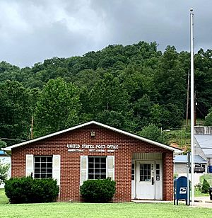
Amherstdale post office
|
|
| Country | United States |
| State | West Virginia |
| County | Logan |
| Area | |
| • Total | 3.01 sq mi (7.79 km2) |
| • Land | 2.99 sq mi (7.75 km2) |
| • Water | 0.02 sq mi (0.05 km2) |
| Elevation | 896 ft (273 m) |
| Population
(2010)
|
|
| • Total | 350 |
| • Density | 117/sq mi (45.2/km2) |
| Time zone | UTC-5 (Eastern (EST)) |
| • Summer (DST) | UTC-4 (EDT) |
| ZIP code |
25607
|
| Area codes | 304 & 681 |
| GNIS feature ID | 1534919 |
| FIPS code | 54-01660 |
Amherstdale is a small community in Logan County, West Virginia, United States. It is located along Buffalo Creek. Amherstdale is a census-designated place (CDP). This means it is an area identified by the U.S. Census Bureau for collecting statistics. It is not an officially incorporated town or city.
The Amherstdale CDP includes several smaller communities. These are Amherstdale itself, along with Becco, Fanco, and Braeholm. In 2010, about 350 people lived in this area.
Before 2010, Amherstdale was part of a larger CDP called Amherstdale-Robinette. Amherstdale has its own post office with the ZIP code 25607.
Community History
Amherstdale was affected by the Buffalo Creek flood disaster. This tragic event caused a lot of damage. Many people lost their homes, and some were injured or died. The community worked hard to recover from this disaster.
Geography
Amherstdale is located in the southeastern part of Logan County. It sits in the valley of Buffalo Creek. To its west and south, Amherstdale is next to the Accoville CDP. To the east, it borders Robinette.
If you travel by road, Amherstdale is about 5.5 miles (8.9 km) northeast of Man. This is where Buffalo Creek meets the Guyandotte River. It is also about 9 miles (14 km) west of Saunders, which is at the beginning of the Buffalo Creek valley.
The Amherstdale CDP covers a total area of about 7.8 square kilometers (3.0 sq mi). A very small part of this area, about 0.05 square kilometers (0.019 sq mi), is water. This means about 0.59% of the area is water.
See also
 In Spanish: Amherstdale (Virginia Occidental) para niños
 | Kyle Baker |
 | Joseph Yoakum |
 | Laura Wheeler Waring |
 | Henry Ossawa Tanner |


