Ammassalik wooden maps facts for kids
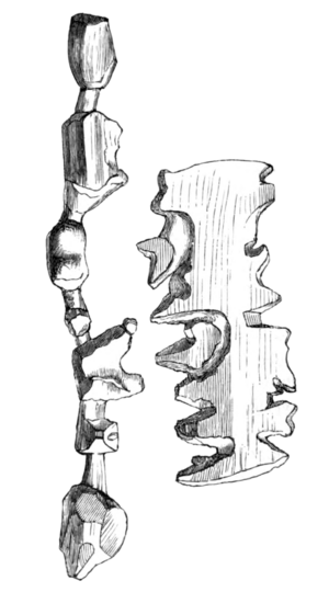
Ammassalik wooden maps are special maps carved from wood. They show the coastlines of Greenland in a way you can feel with your hands. These unique maps were made by the Tunumiit people, who are Eastern Greenland Inuit.
In the 1880s, a Danish explorer named Gustav Frederik Holm led a trip to the Ammassalik coast in eastern Greenland. He met several Inuit communities there. These communities had never met Europeans before. Holm returned to Denmark with a set of three-dimensional wooden maps. These maps showed the coast around Ammassalik. A local man from Umivik named Kunit carved them.
History of the Maps
Kunit first met Gustav Holm on February 8, 1885. He sold Holm some maps that showed the coast from Sermiligak to Kangerdlugsuatsiak. Kunit came back on March 21 with another piece. This piece showed the land between Sermiligak and Kangerdluarsikajik.
When Holm returned home, the maps were placed in the National Museum of Denmark in Copenhagen. Copies of the maps were also sent to a museum in Paris. Later, the original maps were moved to the Greenland National Museum in Nuuk. This museum was created in the mid-1960s.
There is only one other known map like these. It is at the Michigan State University Museum. Experts believe it is likely a copy of Kunit's original work.
In 2000, Post Greenland made a special stamp. It showed the coastal map. This stamp was part of their "Greenland's Cultural Heritage" series. The Greenland National Museum also loaned the maps for an exhibition. This show was called Maps: Finding Our Place in the World. It traveled to museums in Chicago and Baltimore.
What the Maps Show
The Ammassalik wooden maps are amazing because they show the coastline in detail. They include islands, fjords (long, narrow inlets of the sea), and capes (points of land sticking out into the sea). Kunit, the carver, used his knowledge of the land. He included important places like old settlement sites. He also marked areas where salmon could be found. Some parts even showed where the land ice met the sea. These maps were very useful for navigating the complex coast. They helped people understand the shape of the land and sea.
Related Maps
- Marshall Islands stick chart
- Straight-line diagram
 | Leon Lynch |
 | Milton P. Webster |
 | Ferdinand Smith |


