Amo, Indiana facts for kids
Quick facts for kids
Amo, Indiana
|
||
|---|---|---|

Downtown Amo
|
||
|
||

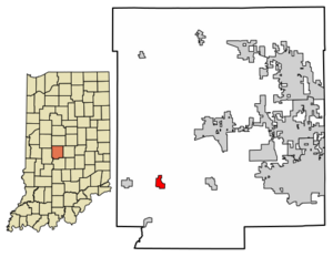
Location of Amo in Hendricks County, Indiana.
|
||
| Country | United States | |
| State | Indiana | |
| County | Hendricks | |
| Township | Clay | |
| Area | ||
| • Total | 0.61 sq mi (1.58 km2) | |
| • Land | 0.61 sq mi (1.58 km2) | |
| • Water | 0.00 sq mi (0.00 km2) | |
| Elevation | 830 ft (250 m) | |
| Population
(2020)
|
||
| • Total | 408 | |
| • Density | 666.67/sq mi (257.45/km2) | |
| Time zone | UTC−5 (EST) | |
| • Summer (DST) | UTC−5 (EST) | |
| ZIP code |
46103
|
|
| Area code | 317 | |
| FIPS code | 18-01450 | |
| GNIS ID | 2397430 | |
Amo is a small town in Hendricks County, Indiana, United States. It's located in Clay Township. In 2020, about 408 people lived there. The town's name, "Amo," means "I love" in Latin.
Contents
The Story of Amo
Amo started as a town called Morristown in 1850. It was founded by Joseph Morris. A few years later, in 1855, its name was changed to Amo. This name comes from a Latin word meaning "I love." Amo officially became a town in 1913.
A special building in Amo, the Amo THI & E Interurban Depot/Substation, was added to the National Register of Historic Places in 2007. This means it's an important historical site.
Town Seal
In 2000, Amo celebrated its 150th birthday! To mark this special event, the town held a contest. Residents and students could design an official "Town Seal." Forty-two designs were submitted.
A local resident named Randy L. Potts won the contest. His design was chosen on May 27, 2000. On June 3, 2000, a U.S. Congressman, David M. McIntosh, presented the new seal to the town.
The seal shows an old mill building with Mill Creek flowing nearby. It also features a railroad track leading towards the Indianapolis skyline. A corn field and a freshly plowed field are also pictured. These parts of the seal show the town's farming history. The outer ring of the seal says "Town of Amo" and "1850," which is the year the town was founded.
Geography of Amo
Amo is a small town, covering about 0.63 square miles (1.58 square kilometers) of land.
Vandalia Trail
The Vandalia Trail is a cool path used for fun outdoor activities. You can go hiking, biking, or even horseback riding on it. This trail is still being developed.
The plan is for the Vandalia Trail to connect to the National Road Heritage Trail. This bigger trail will be about 150 miles long! It will stretch from Terre Haute to Richmond. It follows old railroad paths and the historic National Road.
A 3-mile section of the trail connects Amo to Coatesville. This part is taken care of by the Hendricks County Parks and Recreation and the Hendricks County Trail Association.
Population Information
| Historical population | |||
|---|---|---|---|
| Census | Pop. | %± | |
| 1880 | 200 | — | |
| 1920 | 274 | — | |
| 1930 | 278 | 1.5% | |
| 1940 | 288 | 3.6% | |
| 1950 | 354 | 22.9% | |
| 1960 | 437 | 23.4% | |
| 1970 | 422 | −3.4% | |
| 1980 | 444 | 5.2% | |
| 1990 | 380 | −14.4% | |
| 2000 | 414 | 8.9% | |
| 2010 | 401 | −3.1% | |
| 2020 | 408 | 1.7% | |
| U.S. Decennial Census | |||
2010 Census
In 2010, 401 people lived in Amo. There were 141 households, which are groups of people living together. Most of the people living in Amo were White.
About 29% of the residents were under 18 years old. The average age in Amo was about 38 years old. The town had a nearly equal number of males and females.
Education
Amo is home to Mill Creek West Elementary. This is one of two elementary schools in the Mill Creek Community School Corporation.
Notable people
- Chase A. Clark, a United States federal judge and the 18th Governor of Idaho.
See also
 In Spanish: Amo (Indiana) para niños
 | Sharif Bey |
 | Hale Woodruff |
 | Richmond Barthé |
 | Purvis Young |


