An Caisteal (Coll) facts for kids
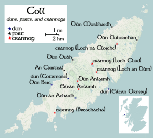
An Caisteal (which means "The Castle" in English) is an ancient hill fort found on the island of Coll. Coll is one of the Inner Hebrides islands, located off the west coast of Scotland. An Caisteal is a cool historical spot! Not far from An Caisteal, about 1.1 kilometers (1200 yards) to the northeast, is a place called Dùn Foulag. People once thought Dùn Foulag was also an old fort (called a dun), but now we know it's just a natural rocky hill.
Contents
What is An Caisteal?
An Caisteal is known by locals as "The Castle." It sits on the island of Coll, which is part of the Inner Hebrides. You can find it about 300 meters (984 feet) west-northwest of Ballyhaugh farmhouse. From An Caisteal, you can see another old fort called Dùn Beic to the south. Dùn Foulag is also visible to the northeast.
Dùn Foulag: A Natural Hill, Not a Fort
In the early 1900s, a historian named Erskine Beveridge thought Dùn Foulag was an old fort. He believed he saw parts of a defensive wall there. However, today, experts think it's just a natural rocky hill.
In 1972, the Ordnance Survey (OS), which maps the UK, visited Dùn Foulag. They found no signs of anything ancient. The Royal Commission on the Ancient and Historical Monuments of Scotland (RCAHMS) now calls it a "natural feature." What Beveridge thought was a wall is now believed to be parts of a more modern building. The "fallen stones" he saw were just beach stones.
Exploring the Fort's Design
An Caisteal itself sits on a rocky area that rises about 12 meters (39 feet) above the ground around it. Three sides of this rock are very steep cliffs, making it hard to reach. It's almost like a natural fortress!
You can only get to the fort from the north side. There's a natural, narrow path that goes up around the cliff face.
How the Walls Were Built
The main wall of the fort followed the top of this rocky area. On the north and east sides, the wall was on a terrace. On the south side, it followed the edge of the cliff. This main wall enclosed an area about 29 meters (95 feet) long from northwest to southeast, and 26 meters (85 feet) wide.
The RCAHMS believes that only a small part of this area could have been lived in. Much of the space was covered by bare rock. Today, you can only see a pile of rubble where the wall once stood on the east side. However, on the west and southwest, parts of the wall are still about 0.5 meters (1.6 feet) high.
There are also signs of an outer wall. This wall would have protected the easiest way to get into the fort. It lined a lower part of the terrace on the northwest side.
When Erskine Beveridge visited An Caisteal, he found a couple of "doubtful" hammerstones. These are stones that might have been used as tools.
 | Aaron Henry |
 | T. R. M. Howard |
 | Jesse Jackson |


