
Coll facts for kids
| Gaelic name | Cola |
|---|---|
| Meaning of name | Pre-Celtic and unclear |
 View of Arinagour |
|
| OS grid reference | NM207584 |
| Coordinates | 56°38′N 6°33′W / 56.64°N 6.55°W |
| Physical geography | |
| Island group | Mull |
| Area | 7,685 ha (29.67 sq mi) |
| Area rank | 18 |
| Highest elevation | Ben Hogh 106 m (348 ft) |
| Administration | |
| Sovereign state | United Kingdom |
| Country | Scotland |
| Council area | Argyll and Bute |
| Demographics | |
| Population | 195 |
| Population density | 2.5/km2 (6.5/sq mi) |
| Largest settlement | Arinagour |
| References | |
| Designated: | 31 March 1995 |
| Reference #: | 723 |
Coll (Scottish Gaelic: Cola) is a beautiful island located west of the Isle of Mull in Scotland. It's part of the Inner Hebrides group of islands. Coll is famous for its amazing sandy beaches, which often turn into huge sand dunes. It's also a special place for rare birds like the corncrake and is home to the historic Breacachadh Castle. The island is part of the Argyll and Bute council area.
Contents
What is Coll Made Of?
Coll is mostly made of a very old type of rock called gneiss. This rock is part of something called the Lewisian complex, which includes some of the oldest rocks in the world! These rocks were formed billions of years ago and have been changed by heat and pressure deep inside the Earth.
You can also find cracks in the rocks called faults, especially on the eastern side of the island. There are also dolerite and camptonite dykes, which are like walls of rock that formed when molten rock pushed up through cracks.
Near the coast, you'll see sand from old beaches that have been lifted up over time. In some low areas, there's alluvium, which is soil carried by water. The western and northern parts of Coll have lots of blown sand (sand moved by the wind), forming those big dunes. There are also areas of peat, which is decayed plant matter, especially southwest of Arinagour.
Exploring Coll's Geography
Coll is about 13 miles (21 km) long and 3 miles (5 km) wide. It has a population of around 150 people. As mentioned, its sandy beaches are a big feature, often leading to large sand dunes.
The highest point on Coll is a ridge called Ben Hogh, located in the middle-west of the island. It has two peaks, with the highest reaching 106 meters (348 feet) tall.
Main Places on Coll
Arinagour (Scottish Gaelic: Àirigh nan Gobhar) is the main village on Coll. It's located on the east coast, at the end of Loch Eatharna. Here are some other places where people live on the island:
- Acha (Scottish Gaelic: An t-Achadh): A small farming settlement about 3 miles (5 km) southwest of Arinagour.
- Arileod (Scottish Gaelic: Àirigh Leòid): Found on the west coast, about 4.5 miles (7 km) southwest of Arinagour.
- Arnabost (Scottish Gaelic: Àrnabost): About 2 miles (3 km) northwest of Arinagour. This is a key spot for roads connecting different parts of the island.
- Ballyhaugh (Scottish Gaelic: Baile Hogh): Located on the northern part of Hough Bay, about 3 miles (5 km) west of Arinagour.
- Bousd (Scottish Gaelic: Babhsta): About 4.5 miles (7 km) northeast of Arinagour.
- Clabhach (Scottish Gaelic: A' Chlabaich): On the northwest coast, about 3 miles (5 km) northwest of Arinagour.
- Crossapol (Scottish Gaelic: Crosabol): Located on the southwest coast.
- Totronald (Scottish Gaelic: Tobhta Raghnaill): On the west coast, about 4.5 miles (7 km) southwest of Arinagour.
- Uig (Scottish Gaelic: Ùig): About 0.5 miles (1 km) northeast of Loch Breachacha.
What Does the Name Coll Mean?
The name Coll might come from the Gaelic word coll, which means 'hazel' (a type of tree). However, old records of the name don't quite match this idea.
An old book from the 600s, called the Life of St Columba, mentions Coll as Colosus. Some experts think this might be a very old name from before the Celtic people arrived. One idea is that it could be linked to the Greek word kolossós, which means a giant statue. This might refer to a large standing stone that used to be on the island, similar to ones found on other Scottish islands.
Another idea comes from Icelandic, where kollur means "a rounded bump," like a rounded mountaintop. This could describe some of Coll's landscape.
A Look at Coll's History
Early Times on Coll
.jpg)
Around the 500s, people from Ireland, called the Gaelics, came to Scotland and created a kingdom called Dál Riata. Coll was part of this kingdom. Later, Coll became part of the Kingdom of the Isles, which was controlled by Norway. After a famous leader named Somerled, it became part of the MacDougall family's lands.
Like many islands in the Hebrides, Coll has several crannógs. These are artificial islands built in lochs, often for protection. Some of Coll's crannógs are thought to be from the time when the Norse people were here. Local stories say that three of them – Dùn Anlaimh, Dùn an Achaidh, and Dùn Dubh – were strongholds used by the Norse.
In 1266, a treaty was signed that gave control of these islands from Norway to the Scottish king. After some conflicts, Coll eventually became part of the Lordship of the Isles.
The MacLeans of Coll
.jpg)
The Clan MacLean became very important in this area. A man named John Garbh, a younger son of a MacLean chief, managed to get Coll and other lands for his family. The Scottish king James II even confirmed this grant.
John Garbh's family became known as the MacLeans of Coll. They built Breachacha Castle on the south coast of Coll as their main home. For 500 years, this branch of the MacLean family lived on Coll. In 1549, a writer described Coll as "a fertile island with a castle and a church, good for fishing and birds, with a very good falcon's nest."
Family Conflicts
When the Lordship of the Isles ended in the late 1400s, the MacLeans of Coll became directly loyal to the king, not to other MacLean chiefs. This caused problems with the main branch of the family, the MacLeans of Duart, who believed they should lead all MacLeans.
This disagreement led to a fight in 1561. The MacLeans of Duart attacked Coll. The MacLeans of Coll asked the Scottish government for help, and the government agreed with them, ordering the Duarts to pay for the damage.
However, in 1583, the new leader of the MacLeans of Duart attacked Coll again, wanting to take the island for himself. A battle took place near Breacachadh Castle at a place called Totronald. The Coll clan won, and it's said they threw the heads of their enemies into a stream, which is still known as "the stream of the heads."
Troubles with the Earl of Argyll

In the late 1600s, the MacLeans of Duart owed money to the Earl of Argyll. This debt came from a time of civil war when the MacLeans had supported the king against other groups. Many people felt the debt was unfair.
The MacLeans of Coll helped the Duart MacLeans by carrying out small attacks on the Earl's lands. The Earl of Argyll was also a strong supporter of the Scottish Reformation, a religious movement. In 1679, he attacked Coll as revenge for their support of the Duarts. Breachacha Castle surrendered. However, in 1681, the Earl was arrested for going against King James VII, and Coll was given back to the MacLeans of Coll.
Leaving Coll

_(14598330869).jpg)
In the late 1700s, about 1,000 people lived on Coll, making a living from farming and fishing. But after the Napoleonic Wars ended, the market for seaweed (kelp), which was important for the island's economy, collapsed. Then, the Highland Potato Famine hit, causing great hardship.
By the mid-1800s, half of Coll's population had decided to leave. Many moved to places like Australia, Canada, or South Africa to find a better life.
In 1848, the heir to the MacLeans of Coll, Alexander Maclean, moved to South Africa. In 1856, his father, Hugh MacLean, decided to sell the island of Coll.
Coll Today
In the 2011 census, Coll's population was 195 people. This was an increase of almost 19% from ten years before, which is great news for the island!
Getting Around Coll

Coll has two main roads. The busiest place on the island is Arinagour. Just south of Arinagour is the Caledonian MacBrayne ferry terminal. The ferry connects Coll to Oban on the mainland and to the nearby island of Tiree. There's also a weekly ferry that goes to Barra.
Coll also has its own small airport (COL), located between Uig and Arileod. A company called Hebridean Air Services flies small planes from Coll to Oban, Tiree, and Colonsay.
| Preceding station | Ferry | Following station | ||
|---|---|---|---|---|
| Tiree | Caledonian MacBrayne Ferry |
Oban |
Coll's Economy and Community

In 2012, Princess Anne officially opened Coll's new community center, An Cridhe, and a hostel called Coll Bunkhouse. These places were built by the local community to provide important facilities and a social hub for everyone on the island. An Cridhe now hosts many events, like a half marathon, the Coll Show, and different festivals for music, comedy, and wildlife.
In 2013, Coll was given 'dark skies' status, making it the second place in Scotland to have this special recognition. This means there are no street lights and very little light pollution, so on clear nights, you can see the stars incredibly well. In winter, you might even see the amazing Northern Lights!
The charity Project Trust, which helps young people volunteer overseas, has been based on Coll since 1974.
Amazing Wildlife on Coll

Coll is a fantastic place for wildlife! There's a large RSPB nature reserve on the western side of the island. One of the most special birds here is the rare corncrake. The way farmers on Coll traditionally work their land helps this bird, which used to be common across Britain, to survive.
In 2010, a group of very rare short-necked oil beetles was discovered on Coll. These beetles were thought to be extinct in the UK! They are now only known to live in southern England and on Coll. These beetles can't fly and are parasites on ground-dwelling bees, which makes their presence on Coll a bit of a mystery.
Coll in Stories


Mairi Hedderwick, a famous illustrator and author, used to live on Coll. She used the island as the setting for her popular Katie Morag series of children's books. In the books, Coll is called the Isle of Struay.
The island is also mentioned in one of Alexander McCall Smith's books, The Charming Quirks of Others. In this story, the main character, Isabelle Dalhousie, talks about Coll as a possible place for a honeymoon.
Images for kids
-
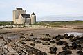
Breacachadh Castle, a historic fortress on Coll.

