
Tiree facts for kids
| Gaelic name | Tiriodh |
|---|---|
| Norse name | Tyrvist |
| Meaning of name | Gaelic for 'land of corn' |
| OS grid reference | NL999458 |
| Coordinates | 56°30′N 6°53′W / 56.5°N 6.88°W |
| Physical geography | |
| Island group | Mull |
| Area | 7,834 ha (30.25 sq mi) |
| Area rank | 17 |
| Highest elevation | Ben Hynish 141 m (463 ft) |
| Administration | |
| Sovereign state | United Kingdom |
| Country | Scotland |
| Council area | Argyll and Bute |
| Demographics | |
| Population | 653 |
| Population density | 8.3/km2 (21/sq mi) |
| Largest settlement | Scarinish |
Tiree (which is Tiriodh in Gaelic) is the most western island in a group called the Inner Hebrides in Scotland. This flat island is southwest of Coll. It covers about 78 square kilometers (30 square miles) and has around 650 people living there.
The land on Tiree is very good for growing crops. Most people on the island work in crofting (a type of small farming), tourism, or fishing. Tiree, like the island of Colonsay, gets a lot of sunshine in late spring and early summer. It often has more sunny hours than most places in the United Kingdom. Tiree is also a very popular place for windsurfing. Some people even call it the "Hawaii of the north" because of this. A big surfing event called the Tiree World Classic is often held here.
Contents
Island History

_(14598330869).jpg)
Tiree is famous for a few historical sites. One is the Dùn Mòr broch, which is an ancient stone tower from the 1st century AD. There's also the prehistoric carved Ringing Stone. The Ceann a' Mhara headland is known for its many birds.
Stories about Saint Columba and Tiree were written down by Adomnan of Iona. Saint Columba was a very important religious leader.
In one story, Columba told a monk named Berach not to sail straight from Iona to Tiree. He advised him to take a different path. But the monk didn't listen and sailed directly. On his way, a huge whale came out of the sea and almost destroyed their boat. Columba gave the same warning to another person, Baithéne mac Brénaind. Baithéne said that both he and the whale were in God's hands. Columba then told him to go, saying his faith would keep him safe. When Baithéne set off, the whale appeared. He raised his hands and blessed it, and the whale went back into the ocean.
Adomnan also wrote that Baithéne mac Brénaind asked Columba to pray for good wind to get him to Tiree. Columba did, and Baithéne crossed the sea from Iona to Tiree with full sails. In another story, Columba told a monk to go to a monastery on Tiree and stay there for seven years as a form of penance. There's also a story about Columba sending some bad spirits away from Iona. These spirits then went to Tiree to bother the monks there instead. Adomnan also mentioned that there was more than one monastery on Tiree back then. He said that Baithéne mac Brénaind had been the leader of one of these monasteries.
In 1549, a writer named Donald Munro described Tiree as a "fertile and fruitful country." He said it had two churches, a freshwater loch with an old castle. He noted that no other place could be better for growing corn. It was also good for wild birds and fish, and had a good harbor for boats.
By 1770, half of the island was farmed by fourteen farmers. They had drained land to grow hay and for animals to graze. Instead of selling live cattle, which often got tired and sold for low prices, they started to export salted beef in barrels. This helped them get better prices. The rest of the island was rented to 45 groups of people who worked together on farms. This way of farming likely came from older clan traditions. They would choose their field strips each year by drawing lots. They also decided together when to plant and harvest crops. Reports from 1774 said that people on Tiree were "well-clothed and well-fed." They had plenty of corn and cattle.
The name Tiree comes from Tìr Iodh, which means 'land of the corn'. This name dates back to the 6th century. At that time, Saint Columba (who died in 597) was a Celtic missionary and abbot. Tiree used to provide grain for the religious community on the island of Iona, which is southeast of Tiree. Several early monasteries once existed on Tiree itself. Many places still have stone cross-slabs from this time. Examples include St Patrick's Chapel and Soroby.
The Skerryvore lighthouse is about 12 miles (19 km) southwest of Tiree. It was built between 1838 and 1844 by Alan Stevenson. It was a very difficult project.
A large Royal Air Force (RAF) base was built on Tiree during World War II. This base became Tiree Airport in 1947. There were also several RAF radar stations on the island during the war. These stations helped track aircraft. After the war, there was an RAF radar station at Beinn Ghott.

Island Geography
The main village on Tiree is Scarinish. Other small places where people live include Hynish and Sandaig. Both of these places have small museums you can visit.
The highest point on Tiree is Ben Hynish. It is in the south of the island and rises to 141 meters (463 feet) high.
Getting Around Tiree
CalMac operates a ferry service to Scarinish. The ferry leaves from Oban on the mainland every day. The trip takes about four hours. The ferry also stops at Arinagour on Coll. Once a week, the ferry goes to Castlebay on Barra. Fewer services run in the winter.
Tiree Airport is located at Crossapol. Loganair has daily flights to Glasgow International. Hebridean Air Services flies to Coll and Oban.
Most roads on Tiree are single-track roads, just like on many other small islands. This means they are only wide enough for one car at a time. There are special spots called 'pockets' where cars can wait to let other cars pass or to overtake.
| Preceding station | Ferry | Following station | ||
|---|---|---|---|---|
| Coll | Caledonian MacBrayne Ferry |
Oban | ||
| Coll | Caledonian MacBrayne Ferry (limited service, summer only) |
Castlebay |
Weather on Tiree
-GB.png)
Tiree has a maritime climate, which means it has cool summers and mild winters. This is similar to the rest of western Scotland. Even though Tiree is at the same latitude as Labrador in Canada, snow and frost are rare. If they do happen, they don't last long. Weather information is collected at the island's airport. The coldest temperature recorded recently was -5.8 degrees Celsius (21.6 degrees Fahrenheit) in December 2010. The ocean keeps the summer temperatures much cooler than places in Europe at the same latitude. Winter temperatures are similar to those in coastal southern England.
| Climate data for Tiree, 9m asl, 1981–2010, Extremes 1951– | |||||||||||||
|---|---|---|---|---|---|---|---|---|---|---|---|---|---|
| Month | Jan | Feb | Mar | Apr | May | Jun | Jul | Aug | Sep | Oct | Nov | Dec | Year |
| Record high °C (°F) | 12.3 (54.1) |
12.9 (55.2) |
15.2 (59.4) |
19.8 (67.6) |
23.4 (74.1) |
25.0 (77.0) |
26.1 (79.0) |
25.0 (77.0) |
21.2 (70.2) |
19.1 (66.4) |
14.6 (58.3) |
13.2 (55.8) |
26.1 (79.0) |
| Mean daily maximum °C (°F) | 7.8 (46.0) |
7.7 (45.9) |
8.7 (47.7) |
10.4 (50.7) |
13.0 (55.4) |
14.8 (58.6) |
16.3 (61.3) |
16.4 (61.5) |
15.0 (59.0) |
12.5 (54.5) |
10.1 (50.2) |
8.3 (46.9) |
11.8 (53.2) |
| Mean daily minimum °C (°F) | 3.4 (38.1) |
3.1 (37.6) |
3.9 (39.0) |
5.1 (41.2) |
7.1 (44.8) |
9.5 (49.1) |
11.2 (52.2) |
11.4 (52.5) |
10.0 (50.0) |
8.0 (46.4) |
5.6 (42.1) |
3.9 (39.0) |
6.9 (44.4) |
| Record low °C (°F) | −6.4 (20.5) |
−6.1 (21.0) |
−4.8 (23.4) |
−4.4 (24.1) |
−0.3 (31.5) |
2.3 (36.1) |
5.4 (41.7) |
4.9 (40.8) |
1.4 (34.5) |
−0.3 (31.5) |
−3.9 (25.0) |
−7 (19) |
−7 (19) |
| Average rainfall mm (inches) | 137.8 (5.43) |
101.3 (3.99) |
103.0 (4.06) |
72.8 (2.87) |
59.6 (2.35) |
65.0 (2.56) |
79.7 (3.14) |
106.9 (4.21) |
112.0 (4.41) |
149.5 (5.89) |
135.8 (5.35) |
131.7 (5.19) |
1,255.1 (49.41) |
| Average rainy days (≥ 1.0 mm) | 20.2 | 16.2 | 18.3 | 12.5 | 11.9 | 11.9 | 14.1 | 15.0 | 16.0 | 19.6 | 19.5 | 19.4 | 194.4 |
| Mean monthly sunshine hours | 39.0 | 69.9 | 111.1 | 175.2 | 238.8 | 205.5 | 174.4 | 163.3 | 128.2 | 88.4 | 46.8 | 36.0 | 1,476.6 |
| Source 1: Met Office | |||||||||||||
| Source 2: Royal Dutch Meteorological Institute/KNMI | |||||||||||||
Tiree's Economy
The Southern Hebrides agency says that farming and fishing are still important for Tiree's income. However, tourism is becoming more and more important to the island's economy. The rich machair lands on the island are great for good quality farming and crofting.
The Tiree Community Development Trust has started a project for a large, community-owned wind turbine. This turbine can produce 950 kilowatts of power. This is the fourth such big project in Scotland. The first three were on the islands of Gigha and Westray, and at Findhorn Ecovillage. There are also plans for a large offshore wind farm called The Argyll Array near Skerryvore.
Tiree is a popular place for family holidays. The Discover Tiree Web site, started in 2003, gives information to visitors. Tourists like the beaches and the many crofts. They also enjoy seeing the "traditional blackhouses and white houses." Many of these still have their charming thatched roofs. There are also unique 'pudding houses' where white mortar stands out against dark stone. A dozen blackhouses, with roofs made of local marram grass, can still be found on Tiree.
Tiree is very popular for windsurfing. The island regularly hosts the Tiree Wave Classic event. It was also the location for the Corona Extra PWA World Cup Finals in 2007. Surfing clubs from universities like Edinburgh, Aberdeen, and Glasgow often visit the island. There is also a radar station that tracks civil aircraft.
In 2011, the island's population was 653 people. This was a drop of over 15% since 2001, when there were 770 people living there. During the same time, the population of all Scottish islands grew by 4%.
Tiree has a long history of making spirits. A distillery was set up to bring back the island's whisky heritage. As of 2019, it is making Tyree Gin. The distillery also plans to make Scotch Whisky. An article from April 2020 about the Tiree Whisky Company says they started making gin on the island again in 2019. It doesn't mention plans for whisky. This company is said to be the first legal distillery on the island in over 200 years. Making spirits was banned in 1802. In 2020, the company was selling a Speyside whisky called The Cairnsmuir, but it was not made on Tiree.
Culture and Media

The island is known for its special buildings. These include 'blackhouses' and 'white houses'. Many still have their traditional thatched roofs. There are also unique 'pudding' or 'spotted houses'. In these, only the mortar (the cement between the stones) is painted white.
Tiree has a good number of people who speak Gaelic. In 2001, 368 residents (47.8%) spoke Gaelic. By 2011, this number went down to 240 people (38.3%). However, this is still the highest percentage of Gaelic speakers in the Inner Hebrides.
Since 2010, the island has hosted the yearly Tiree Music Festival. It is held in the car park of the island hall, 'An Talla'. In 2012, Tiree was featured on the BBC Programme Coast for a second time. The show talked about the brave actions of RAF weather forecasters during World War II. They flew dangerous missions into Atlantic storms.
Tiree is the subject of a traditional Scottish song called "Dark Island." This song tells the story of a ship leaving Oban. It passes the "isle of my childhood," Tiree. Tiree is also mentioned in Enya's 1988 song "Orinoco Flow." The island is also in the song "Western Ocean" by Skipinnish. This is a traditional Scottish band co-founded by Angus MacPhail, who is from Tiree.
The Tiree Songbook is an album of songs. Some are from Na Bàird Thirisdeach, a 20th-century book of Tiree songs. Others are new songs about the island. The album won the Community Project of the Year award at the Scots Trad Music Awards in 2017.
Images for kids
-
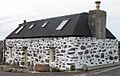
A restored 'spotted house'.
-
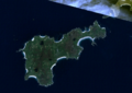
Satellite image of Tiree.


