Ancelle facts for kids
Quick facts for kids
Ancelle
|
||
|---|---|---|

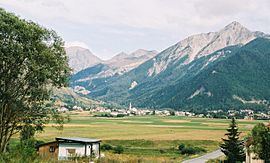
The hamlet of St Hillaire, in Ancelle
|
||
|
||
| Country | France | |
| Region | Provence-Alpes-Côte d'Azur | |
| Department | Hautes-Alpes | |
| Arrondissement | Gap | |
| Canton | Saint-Bonnet-en-Champsaur | |
| Intercommunality | Champsaur-Valgaudemar | |
| Area
1
|
50.66 km2 (19.56 sq mi) | |
| Population
(Jan. 2019)
|
917 | |
| • Density | 18.101/km2 (46.882/sq mi) | |
| Time zone | UTC+01:00 (CET) | |
| • Summer (DST) | UTC+02:00 (CEST) | |
| INSEE/Postal code |
05004 /05260
|
|
| Elevation | 1,160–2,779 m (3,806–9,117 ft) (avg. 1,350 m or 4,430 ft) |
|
| Website | http://www.ancelle.fr/ | |
| 1 French Land Register data, which excludes lakes, ponds, glaciers > 1 km2 (0.386 sq mi or 247 acres) and river estuaries. | ||
Ancelle is a small town, also called a commune, located in southeastern France. It is part of the Hautes-Alpes department and the Provence-Alpes-Côte d'Azur region. As of January 2019, about 917 people live in Ancelle.
Getting Around Ancelle
Roads and Travel
Ancelle is connected by several local roads that help people travel in and out of the village. These include the D13, D213, and D514 roads.
The N94 road goes around Ancelle. This means it doesn't pass directly through the village but helps connect it to other places nearby.
Nature and Landscape
The area around Ancelle is very hilly and beautiful. It is located near the edge of the Écrins National Park, which is a large protected natural area known for its mountains and valleys.
The Rouanne River flows through the village of Ancelle, adding to its natural scenery.
See also
 In Spanish: Ancelle para niños
 | Audre Lorde |
 | John Berry Meachum |
 | Ferdinand Lee Barnett |


