Andersson Island facts for kids

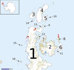
Andersson Island (labelled 9) amongst the island chain off the tip of the Antarctic Peninsula
|
|
| Geography | |
|---|---|
| Location | Antarctic Sound |
| Coordinates | 63°35′S 56°35′W / 63.583°S 56.583°W |
| Archipelago | Joinville Island group |
| Adjacent bodies of water | Hope Bay |
| Length | 1.9 km (1.18 mi) |
| Highest elevation | 435 m (1,427 ft) |
| Administration | |
| Administered under the Antarctic Treaty System | |
Andersson Island is a volcanic island located near the tip of the Antarctic Peninsula in Antarctica. It's about 7 miles (11 kilometers) long and 4 miles (6.4 kilometers) wide. This island is part of a group of islands formed by volcanoes, known as the James Ross Island Volcanic Group.
Contents
Discovering and Naming Andersson Island
Andersson Island was first explored by the Swedish Antarctic Expedition between 1901 and 1904. This expedition was led by a famous explorer named Otto Nordenskjöld.
How the Island Got Its Name
When it was first found, the island was named "Uruguay Island." This was to honor an Argentine ship called the Uruguay. This ship played a very important role in 1903 by rescuing the Swedish Antarctic Expedition members after their ship was wrecked.
However, the name was changed on November 21, 1949. The reason for the change was to avoid confusion with another island, also called Uruguay Island, which is located off the Graham Coast.
The island was then renamed Andersson Island after Dr. Johan Gunnar Andersson. He was a Swedish geologist (someone who studies rocks and the Earth) and was also part of the Swedish Antarctic Expedition. He lived from 1874 to 1960.
Location and Features
Andersson Island is found at the eastern end of the Tabarin Peninsula. It's a high island, meaning it rises quite a bit above the sea. The island is located in the Antarctic Sound, which is a body of water in the Antarctic region.
See also
 In Spanish: Isla Andersson para niños


