Angwin, California facts for kids
Quick facts for kids
Angwin, California
|
|
|---|---|

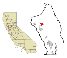
Location in Napa County and the state of California
|
|
| Country | |
| State | |
| County | Napa |
| Area | |
| • census-designated place | 4.87 sq mi (12.62 km2) |
| • Land | 4.83 sq mi (12.51 km2) |
| • Water | 0.04 sq mi (0.11 km2) 0.86% |
| Elevation | 1,749 ft (533 m) |
| Population
(2020)
|
|
| • census-designated place | 2,633 |
| • Density | 545.25/sq mi (210.52/km2) |
| • Metro | 7,468,390 |
| Time zone | UTC-8 (Pacific (PST)) |
| • Summer (DST) | UTC-7 (PDT) |
| ZIP codes |
94508, 94576
|
| Area code(s) | 707 |
| FIPS code | 06-02168 |
| GNIS feature IDs | 1657934; 2407744 |
Angwin is a small community in Napa County, California. It's known for being home to Pacific Union College. Angwin is located in the northern part of the San Francisco Bay Area. In 2020, about 2,633 people lived there. The area uses the 707 phone code and has two ZIP codes: 94508 and 94576. It is in the Pacific time zone.
Contents
History of Angwin
The town of Angwin is named after a man named Edwin Angwin (1841–1919). In 1875, he bought a piece of land about 200 acres (0.81 km2) big on Howell Mountain. He then started a place called the Angwin Resort. Over time, Mr. Angwin owned a lot more land, almost 1,600 acres (6.5 km2) in the area by the 1900s.
Before 1875, the land was part of a larger area called Rancho La Jota. This land belonged to William Campbell Watson. Mr. Watson started selling parts of the Rancho in 1875, and Edwin Angwin bought one of the first pieces. Soon, a community began to grow around the successful Angwin Resort.
In 1909, a college called Healdsburg College (which used to be Healdsburg Academy) bought the Angwin Resort for $60,000. This college, which is part of the Seventh-day Adventist Church, moved from Healdsburg to Angwin and became Pacific Union College.
A news report from 1985 said that more than 80% of the people living in Angwin were part of the Seventh-day Adventist Church.
In August 2020, everyone in Angwin had to leave their homes because of a large wildfire called the Hennessey Fire.
Geography and Climate
Angwin covers a total area of about 4.9 square miles (13 km2). Most of this area is land, with a very small part being water.
The town is located within a special wine-growing area called the Howell Mountain AVA.
Angwin's Weather
Pacific Union College in Angwin has been recording weather information since 1940. This helps the National Weather Service understand local weather patterns.
- Temperatures: In January, the average high temperature is about 52.2°F (11.2°C), and the average low is 37.9°F (3.3°C).
- Hot and Cold Days: On average, there are about 35 days a year when the temperature reaches 90°F (32°C) or higher. There are also about 25 days when the temperature drops to 32°F (0°C) or lower.
- Temperature Records: The hottest temperature ever recorded was 110°F (43°C) on July 15, 1972. The coldest was 14°F (-10°C) on December 9, 1972.
- Rainfall: Angwin gets about 40.60 inches (103.1 cm) of rain each year. The year 1983 was the wettest, with 88.89 inches (225.8 cm) of rain. The driest year was 2020, with only 16.28 inches (41.4 cm).
- Snowfall: On average, Angwin gets about 2.0 inches (5.1 cm) of snow each year. The most snow in one year was 23.3 inches (59 cm) in 1952.
| Climate data for Angwin Pacific Union College, California (1991–2020 normals, extremes 1952–present) | |||||||||||||
|---|---|---|---|---|---|---|---|---|---|---|---|---|---|
| Month | Jan | Feb | Mar | Apr | May | Jun | Jul | Aug | Sep | Oct | Nov | Dec | Year |
| Record high °F (°C) | 77 (25) |
78 (26) |
84 (29) |
91 (33) |
101 (38) |
106 (41) |
110 (43) |
107 (42) |
108 (42) |
99 (37) |
86 (30) |
75 (24) |
110 (43) |
| Mean maximum °F (°C) | 66.4 (19.1) |
68.6 (20.3) |
75.2 (24.0) |
82.0 (27.8) |
87.5 (30.8) |
95.4 (35.2) |
96.8 (36.0) |
96.6 (35.9) |
94.9 (34.9) |
87.1 (30.6) |
73.9 (23.3) |
64.6 (18.1) |
99.6 (37.6) |
| Mean daily maximum °F (°C) | 53.7 (12.1) |
55.9 (13.3) |
60.3 (15.7) |
65.9 (18.8) |
72.7 (22.6) |
80.0 (26.7) |
84.6 (29.2) |
84.3 (29.1) |
81.3 (27.4) |
72.4 (22.4) |
59.8 (15.4) |
52.7 (11.5) |
68.6 (20.3) |
| Daily mean °F (°C) | 46.5 (8.1) |
47.8 (8.8) |
50.6 (10.3) |
54.1 (12.3) |
59.7 (15.4) |
65.7 (18.7) |
69.4 (20.8) |
69.1 (20.6) |
67.4 (19.7) |
61.1 (16.2) |
51.3 (10.7) |
45.8 (7.7) |
57.4 (14.1) |
| Mean daily minimum °F (°C) | 39.3 (4.1) |
39.7 (4.3) |
40.9 (4.9) |
42.3 (5.7) |
46.7 (8.2) |
51.3 (10.7) |
54.1 (12.3) |
53.9 (12.2) |
53.4 (11.9) |
49.7 (9.8) |
42.8 (6.0) |
38.8 (3.8) |
46.1 (7.8) |
| Mean minimum °F (°C) | 29.5 (−1.4) |
31.9 (−0.1) |
34.3 (1.3) |
36.8 (2.7) |
41.9 (5.5) |
46.5 (8.1) |
50.3 (10.2) |
49.8 (9.9) |
46.1 (7.8) |
40.3 (4.6) |
33.3 (0.7) |
29.1 (−1.6) |
27.4 (−2.6) |
| Record low °F (°C) | 19 (−7) |
20 (−7) |
23 (−5) |
25 (−4) |
27 (−3) |
33 (1) |
32 (0) |
39 (4) |
32 (0) |
27 (−3) |
24 (−4) |
14 (−10) |
14 (−10) |
| Average precipitation inches (mm) | 7.80 (198) |
7.59 (193) |
5.50 (140) |
2.37 (60) |
1.56 (40) |
0.36 (9.1) |
0.01 (0.25) |
0.04 (1.0) |
0.17 (4.3) |
1.92 (49) |
4.09 (104) |
8.30 (211) |
39.71 (1,009) |
| Average precipitation days (≥ 0.01 in) | 13.3 | 11.8 | 10.7 | 7.5 | 4.5 | 1.2 | 0.1 | 0.2 | 1.1 | 4.1 | 8.8 | 13.5 | 76.8 |
| Source: NOAA | |||||||||||||
People of Angwin
| Historical population | |||
|---|---|---|---|
| Census | Pop. | %± | |
| 2020 | 2,633 | — | |
| U.S. Decennial Census | |||
Population in 2010
In 2010, Angwin had a population of 3,051 people. This means there were about 626 people living in each square mile (242 people per km2).
- Ethnic Backgrounds:
* About 69.6% of the people were White. * About 4.6% were African American. * About 0.7% were Native American. * About 11.1% were Asian. * About 0.2% were Pacific Islander. * About 7.7% were from other races. * About 6.2% were from two or more races. * About 20.5% of the people were Hispanic or Latino (of any race).
Most people (67.5%) lived in regular homes. About 30.9% lived in group housing, like college dorms.
- Households: There were 824 households in Angwin.
* About 28.3% of these households had children under 18. * More than half (55.9%) were married couples. * The average household had 2.50 people. * The average family had 2.93 people.
- Age Groups:
* About 13.5% of the population was under 18 years old. * A large group, 37.6%, were between 18 and 24 years old (many likely college students). * The average age in Angwin was 24.4 years.
About 52.1% of homes were owned by the people living in them, and 47.9% were rented.
See also
 In Spanish: Angwin para niños


