
Anisy facts for kids
Quick facts for kids
Anisy
|
||
|---|---|---|
|
||

Anisy
Location in France

Anisy
Location in Normandy
|
||
| Country | France | |
| Region | Normandy | |
| Department | Calvados | |
| Arrondissement | Caen | |
| Canton | Creully | |
| Intercommunality | Cœur de Nacre | |
| Area
1
|
4.19 km2 (1.62 sq mi) | |
| Population
(1999)
|
633 | |
| • Density | 151.07/km2 (391.3/sq mi) | |
| Time zone | UTC+01:00 (CET) | |
| • Summer (DST) | UTC+02:00 (CEST) | |
| INSEE/Postal code |
14015 /14610
|
|
| Elevation | 44–67 m (144–220 ft) (avg. 50 m or 160 ft) |
|
| 1 French Land Register data, which excludes lakes, ponds, glaciers > 1 km2 (0.386 sq mi or 247 acres) and river estuaries. | ||
.svg)
Anisy is a small town, also known as a commune, located in France. It is found in the northwest part of the country.
Contents
Where is Anisy Located?
Anisy is part of the region called Basse-Normandie. It is also in the Calvados department. This area is in the northwest of France.
Facts About Anisy
Anisy is a small place with a population of about 633 people, based on a count from 1999. It covers an area of about 4.19 square kilometers.
What is a Mayor?
The mayor is the leader of a town or city. In Anisy, the mayor was Maurice Lambert from 2008 to 2014. The mayor helps manage the town and its services for the people who live there.
How High is Anisy?
Anisy is located at an average height of 50 meters above sea level. This is like saying how high it is compared to the ocean. The lowest point in the town is 44 meters high, and the highest point is 67 meters high.
Images for kids
-
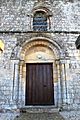
The entrance of the Church of Saint-Pierre.
-
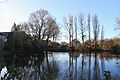
The source of the Dan river.


See also
 In Spanish: Anisy para niños
