Anllóns facts for kids
Quick facts for kids Anllóns |
|
|---|---|

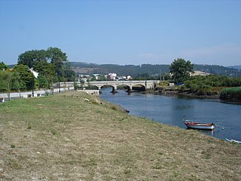
The Anllóns near its mouth
|
|
| Country | |
| Physical characteristics | |
| Main source | Xalo mounts , Province of A Coruña, Galicia. 400 m (1,300 ft) |
| River mouth | Atlantic Ocean |
| Length | 54.4 km (33.8 mi) |
The Anllóns is a river located in Galicia, a region in Spain. It begins its journey high up in the Xalo Mountains, at an elevation of about 400 meters (1,312 feet) above sea level. This river flows for about 54.4 kilometers (33.8 miles) before reaching the Atlantic Ocean. It empties into the ocean through a special inlet called the Ria of Corme and Laxe.
As it travels, the Anllóns river passes through several towns. These include Cabana de Bergantiños, Carballo, Cerceda, Coristanco, and Ponteceso. The river carries a large amount of water, with an average flow of about 9.931 cubic meters (350.7 cubic feet) per second.
A Special River
The Anllóns river is recognized as a very important natural area. In 2001, it was officially declared a Site of Community Importance. This means it is a special place that helps protect important plants and animals in Europe.
Many smaller streams and brooks feed water into the Anllóns river. In its upper part, it receives water from brooks like Graña, Quenxe, Acheiro, Abaixo, Queo, and Bertón. After passing Mount Neme, more water joins from brooks such as Gándara, Bandeira, Vao, Galvar, Portecelo, and Batán. In its lower section, the river is fed by brooks including Lourido, Ponteceso, Prados, and Bouzas.
See also
 In Spanish: Río Allones para niños
- List of rivers of Spain
- Rivers of Galicia
- Way of the Lighthouses
 | Jessica Watkins |
 | Robert Henry Lawrence Jr. |
 | Mae Jemison |
 | Sian Proctor |
 | Guion Bluford |

