Anton R. Roessler facts for kids
Quick facts for kids
Anton R. Roessler
|
|
|---|---|
| Born | c. 1833 |
| Died | 1893 (aged 59–60) |
| Nationality | Austro-Hungarian-American |
| Occupation | Cartographer Geologist |
Anton R. Roessler (around 1833–1893) was an important mapmaker and geologist. He was born in Austria-Hungary and later became an American citizen.
Roessler is famous for creating the only maps that still exist from the first official geological survey of Texas. Many people consider his maps, especially those showing geological areas, to be his best work. He is also seen as one of the top geologists in Texas during the 1800s.
| Top - 0-9 A B C D E F G H I J K L M N O P Q R S T U V W X Y Z |
Early Life and Training
Anton R. Roessler was likely born in a town called Raab in the Kingdom of Hungary. This area was part of the Austrian Empire and is now Győr, Hungary. Some reports say he was born in a nearby village. We don't know much else about his early life.
There are different ideas about when he was born, but the 1880 United States census suggests it was around 1833. It's believed he learned how to make maps in Vienna, Austria. He was very skilled at it. In 1860, he married Octavia Baker in Austin, Texas. She was the daughter of a local doctor.
Mapping Texas: Roessler's Career
Roessler claimed he started observing minerals in Texas as early as 1857. He officially appears in Texas records in late 1858. He worked as an assistant and mapmaker for the first state Geological and Agricultural Survey of Texas. This survey was led by Benjamin Franklin Shumard, the state's chief geologist.
The Shumard Survey
Benjamin Franklin Shumard was born in Pennsylvania in 1820. He became interested in geology and moved to Texas in 1858. A future Texas state geologist, Robert T. Hill, said in 1887 that Roessler was "a hard worker" with "a good scientific education." Hill also noted that Roessler was responsible for much of the accurate map knowledge of Texas at that time.
Shumard's team started their field work in January 1859. They explored many counties in eastern and central Texas. They carefully studied rock layers and recorded geological features. They also measured land heights and noted things like timber, water, minerals, and soil. The team collected samples for more study.
Making maps was hard because existing maps were often incorrect. The survey tried to fix these problems with their new maps. After Shumard left his position in 1860, Roessler and others continued working. The Shumard Survey officially ended when a report about its work was published in 1867.
During the American Civil War
When the American Civil War began, Roessler was still working for the state's geological survey in Austin, Texas. In 1862, the survey was closed. Its offices were turned into a factory for making ammunition. Roessler stayed in Austin and became the chief mapmaker for the Texas State Military Board's arsenal.
However, in February 1865, Roessler suddenly appeared in Louisiana. He shared important information with the Union Army. This included details about Texas's geography, valuable resources, and Confederate defenses. By April of that year, Roessler had helped create a map of Texas in New Orleans. This map was used by Union generals, including George Armstrong Custer. It helped them reoccupy Texas and begin the process of Reconstruction after the war.
Many records from the Texas Geological Survey were lost or destroyed during the Civil War. More were lost in a fire at the Texas State Capitol in 1881. Some people think Roessler might have taken some maps from the state before they were lost.
After the Civil War
In the late 1860s, Roessler worked as a geologist for the United States Land Office in Washington, D.C. He later returned to Austin, Texas.
In 1872, Roessler joined an expedition to explore for minerals with the Texas Land and Copper Association. They traveled across parts of northern and central Texas. Roessler got sick and was injured during parts of this trip. In 1873, he co-wrote an article in German about this exploration.
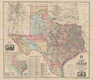
During the 1870s, Roessler created a large map of Texas. He also made 16 maps of individual Texas counties. He published his main Texas map in New York City. At this time, he also worked as a secretary for a company called the Texas Land and Immigration Company of New York.
Roessler spent most of his later life in Austin, Texas. He died in 1893.
Legacy
Anton R. Roessler left a lasting impact on how we understand Texas's geography. Robert T. Hill, a future state geologist, wrote in 1881 that Roessler was responsible for much of the accurate map knowledge of Texas.
Experts like Keith Young say Roessler's maps are some of the earliest examples of detailed geological maps of large areas of Texas. Young also notes that Roessler's work includes the only existing maps from the first Texas Geological Survey. Copies of his maps are kept in important collections, including the United States Geological Survey Library. The Texas Almanac from 1986-87 called Roessler "perhaps the most competent geologist of the period." It also highlighted that he "drew some of the first small-scale maps of Texas' geological regions."
While he wrote some geological papers, his best work was in making maps of Texas.
See Also
 | William L. Dawson |
 | W. E. B. Du Bois |
 | Harry Belafonte |


