Apacilagua facts for kids
Quick facts for kids
Apacilagua
|
|
|---|---|
|
Municipality
|
|

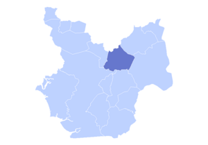
The municipality of Apacilagua highlighted in the Choluteca Department
|
|
| Country | |
| Department | Choluteca |
| Area | |
| • Total | 213.1 km2 (82.3 sq mi) |
| Elevation | 140 m (460 ft) |
| Population
(2015)
|
|
| • Total | 9,075 |
| Climate | Aw |
Apacilagua (say "ah-pah-see-LAH-gwah") is a small town and municipality in Honduras. It is located in the Choluteca area. The town is about 29.3 kilometers (18 miles) northeast of the city of Choluteca.
Apacilagua is found in the northern part of the Choluteca province. It is also close to the border with the El Paraíso Department. The town sits right by the Choluteca River and is along the RN85 road. You can find the Iglesia Catolica Apacilagua, a Catholic church, in the town. The whole municipality covers an area of 213.1 square kilometers (82.3 square miles). In 2015, about 9,075 people lived there.
Contents
History of Apacilagua
When Apacilagua Started
The municipality of Apacilagua was officially created in 1831. Later, during a count of people and places in 1887, it was listed as a municipality. At that time, it was part of the Orocuina District.
Helping with Food and Nutrition
In August 2012, an important center was opened in Apacilagua. It's called the Centro de Documentación e Información para la Seguridad Alimentaria y Nutricional (CEDESAN). This means the "Documentation and Information Center for Food and Nutrition Security." The mayor, Rafael Mendoza, helped open it.
This center works with a bigger program called PRESANCA. PRESANCA aims to make sure everyone in Central America has enough safe and healthy food. Many groups help fund this program. These include the European Union, the Spanish Agency for International Development Cooperation (AECID), the United Nations Development Program (UNDP), and the Government of Finland.
Geography of Apacilagua
Where Apacilagua is Located
The small town of Apacilagua is about 29.3 kilometers (18 miles) northeast of Choluteca. It is in the northern middle part of its province. The town is also not far from the border with the El Paraíso Department.
Rivers and Land Area
Apacilagua is located right on the Choluteca River. It is also found along the RN85 road. The entire municipality covers an area of 213.1 square kilometers (82.3 square miles).
Villages and Hamlets in Apacilagua
The municipality of Apacilagua includes eight main villages, also called aldeas. It also has 149 smaller areas known as hamlets. The eight main villages are:
- Apacilagua (this is the main town of the municipality)
- La Albarrada
- La Garza
- Los Limones
- Los Mezcales
- Monte Grande
- San Felipe
- Somuina
Economic Activities in Apacilagua
Most of the money-making activities in Apacilagua come from farming, raising animals, forestry (working with forests), and fishing. These activities make up 89% of the local economy.
Other activities include:
- Teaching: 1.7%
- Buying and selling goods (wholesale and retail) and vehicle repair: 1.6%
- Making things (manufacturing) and building: 3%
- Other sources: 4.9%
See also
 In Spanish: Apacilagua para niños
 | Dorothy Vaughan |
 | Charles Henry Turner |
 | Hildrus Poindexter |
 | Henry Cecil McBay |


