El Paraíso Department facts for kids
Quick facts for kids
El Paraíso Department
Departamento de El Paraíso
|
|
|---|---|
|
department
|
|

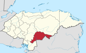
Location of El Paraíso in Honduras
|
|
| Country | |
| Municipalities | 19 |
| Villages | 233 |
| Founded | 28 May 1869 |
| Capital city | Yuscarán |
| Government | |
| • Type | Departmental |
| Area | |
| • Total | 7,383 km2 (2,851 sq mi) |
| Population
(2021)
|
|
| • Total | 502,944 |
| • Density | 68.122/km2 (176.435/sq mi) |
| Time zone | UTC-6 (CDT) |
| Postal code |
13101, 13201
|
| ISO 3166 code | HN-EP |
| HDI (2017) | 0.568 medium · 13th |
| Statistics derived from Consult INE online database: Population and Housing Census 2013 | |
El Paraíso is one of the 18 main areas, called departments, that make up the country of Honduras. Its name means "The Paradise" in Spanish.
This department was created on May 28, 1869. Before that, its land was part of two other departments: Tegucigalpa (now Francisco Morazán) and Olancho. The new department was formed during the time José María Medina was president of Honduras. When it was first created, El Paraíso included important towns like Danlí, Yuscarán, Texiguat, and Guinope. Later, Texiguat moved to another department for a short time but came back to El Paraíso in 1886.
The main city and capital of El Paraíso is Yuscarán. The department shares its borders with other regions. To the north, it's next to Olancho. To the south, it borders Choluteca. To the east, it touches the country of Nicaragua. And to the west, it's next to Francisco Morazán.
El Paraíso covers a total area of about 7,489 square kilometers (2,892 square miles). In 2021, it had a population of over 500,000 people.
Towns and Cities
El Paraíso is divided into several smaller areas called municipalities. Each municipality has its own local government. Here are the 19 municipalities in El Paraíso:
See also
- In Spanish: Departamento de El Paraíso para niños
 | Charles R. Drew |
 | Benjamin Banneker |
 | Jane C. Wright |
 | Roger Arliner Young |

