
Francisco Morazán Department facts for kids
Quick facts for kids
Francisco Morazán Department
Departamento de Francisco Morazán
|
||
|---|---|---|
|
Department
|
||
|
||

Location of Francisco Morazán in Honduras
|
||
| Country | ||
| Municipalities | 28 | |
| Villages | 274 | |
| Established | 28 June 1825 | |
| Capital city | Tegucigalpa | |
| Government | ||
| • Type | Departmental | |
| Area | ||
| • Total | 8,580 km2 (3,310 sq mi) | |
| Population
(2015)
|
||
| • Total | 1,553,379 | |
| • Density | 181.05/km2 (468.91/sq mi) | |
| Time zone | UTC-6 (CDT) | |
| Postal code |
11101, 12101
|
|
| ISO 3166 code | HN-FM | |
| HDI (2021) | 0.677 medium · 1st |
|
| Statistics derived from Consult INE online database: Population and Housing Census 2013 | ||

Francisco Morazán is one of the 18 departments of Honduras. A department is like a state or province in other countries. It is often called FMO for short.
This department is located in the middle part of Honduras. Its capital city is Tegucigalpa, which is also the capital city of all of Honduras. Before 1943, this area was known as the Tegucigalpa department. It was later renamed to honor a national hero named Francisco Morazán.
Contents
Geography and Nature
Francisco Morazán is a very mountainous area. Imagine rugged mountains covered in tall pine trees. The soil here is often rocky and made of clay. But between these mountains, you'll find beautiful valleys, like Guaimaca, Talanga, and Amarateca.
Cloud Forests and Dry Forests
Many of the high mountain peaks in Francisco Morazán are home to special places called cloud forests. These forests are often covered in mist and fog, like La Tigra National Park or Cerro Uyuca. In the very southeastern part of the department, the environment changes to a Pacific dry forest. This type of forest has plants and animals that are used to drier weather.
Montaña de la Flor
In the northern part of the department, you'll find an area called Montaña de la Flor. This place is special because it is home to the Jicaque people, an indigenous group in Honduras.
Size and Population
The Francisco Morazán department covers a total area of about 7,946 square kilometers (about 3,068 square miles). In 2005, it had an estimated population of about 1,680,700 people. This makes it one of the most populated departments in Honduras.
Symbols of the Department
The coat-of-arms and the flag of the Francisco Morazán Department are the same as those used by its capital city, Tegucigalpa.
Cities and Towns: Municipalities
The department of Francisco Morazán is divided into 28 smaller areas called municipalities. Each municipality has its own local government. The capital city, Tegucigalpa, is part of a municipality called Distrito Central.
Here is a list of the municipalities in Francisco Morazán:
- Alubarén
- Cedros
- Curarén
- Distrito Central (capital is Tegucigalpa)
- El Porvenir
- Guaimaca
- La Libertad
- La Venta
- Lepaterique
- Maraita
- Marale
- Nueva Armenia
- Ojojona
- Orica
- Reitoca
- Sabanagrande
- San Antonio de Oriente
- San Buenaventura
- San Ignacio
- San Juan de Flores
- San Miguelito
- Santa Ana
- Santa Lucía
- Talanga
- Tatumbla
- Valle de Ángeles
- Vallecillo
- Villa de San Francisco
Images for kids
-
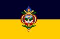
Flag of Tegucigalpa
-
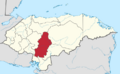
Location of Francisco Morazán in Honduras
See also
- Arnoldo José Avilés García
- In Spanish: Departamento de Francisco Morazán para niños
