Choluteca, Choluteca facts for kids
Quick facts for kids
Choluteca
|
|
|---|---|
|
Municipality
|
|

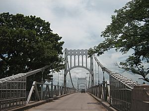
Choluteca bridge
|
|
| Nicknames:
Cholu, Cholutexas
|
|
| Country | |
| Department | Choluteca |
| Municipality | Choluteca |
| Founded | 1522 |
| Villa Title | 1585 |
| City Title | 1845 |
| Government | |
| • Type | Democratic Municipality |
| Area | |
| • Municipality | 1,072 km2 (414 sq mi) |
| Population
(2023 projection)
|
|
| • Municipality | 175,056 |
| • Density | 163.30/km2 (422.94/sq mi) |
| • Urban | 115,906 |
| Abbreviation | Cholu |
| Climate | As |
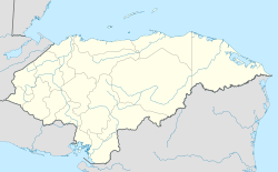
Choluteca is an important city in southern Honduras. It is the capital of the Choluteca department. The city is located between El Salvador and Nicaragua. It is a major stop on the Pan-American Highway. This highway connects many countries in the Americas.
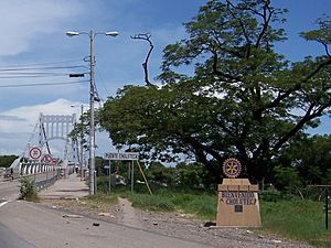
Choluteca is a busy place. It has a large bus station. It also has offices for electricity and water services. The city sits on the Choluteca River. A beautiful silver bridge crosses this river into the city.
With about 175,056 people (in 2023), Choluteca is one of the largest cities in Honduras. It is known as one of the hottest cities in the country.
Contents
History of Choluteca
When Spanish explorers, called conquistadors, came to southern Honduras in 1535, the Chorotega people lived there. In 1541, a town was started by Captain Cristobál de la Cueva. It was called Villa de Xerez de la Frontera de Choluteca.
The Spanish often built towns in important places. This helped them control the land from the local people. Xerex de la Frontera was a key spot. It helped them communicate with nearby areas like Guatemala and Nicaragua.
The Choluteca area had many valuable things. It had rich soil for farming and lots of minerals. This made it one of the wealthiest areas for the Spanish government in Honduras.
At first, Villa de Xerez de la Frontera was part of the Guatemalan government. But in 1580, it became part of the Tegucigalpa, Honduras, municipality. On October 1, 1845, the city was officially named “Choluteca.” This was done by the National Congress under President Coronado Chávez.
There are different ideas about when Choluteca was truly founded. Some historians say 1535, others say 1533 or 1540. However, the year 1535 is the most commonly accepted date for its founding.
Over many years, Choluteca has grown a lot. It has become an important center for history, culture, and business in Honduras.
Hurricane Mitch and Recovery
In 1998, Choluteca was badly damaged by a big storm called Hurricane Mitch. The city received a huge amount of rain in just a few days. This was much more rain than it normally gets in half a year!
The Choluteca River became very wide. It flooded many neighborhoods and villages. Places like Stevensville were heavily damaged. Many people lost their homes and belongings.
A charity called Solar net Village helped rebuild San Ramón, Choluteca. They also helped bring back electricity to other affected areas.
Economy and Products
Choluteca is a very productive area in Honduras. Farmers here grow many important crops. These include sugar, cantaloupe, watermelon, okra, and sweet potato.
The region is also known for its seafood. People here harvest shrimp and fish. They also produce salt. Some valuable precious metals are found in the area too.
Famous People from Choluteca
Choluteca is the birthplace of some famous Hondurans.
José Cecilio del Valle was born here in 1780. He was the first President of Central America. His childhood home, called Casa Valle, is on the main square. Today, it is a cultural center. It has the local library and a tourist information center. You can even see his house pictured on the back of the 100-lempira banknote!
Dania Prince is another famous person from Choluteca. She won the Miss Earth beauty pageant in 2003. She is the only Honduran to win such a big international beauty contest.
Transportation
The city has an airport called Choluteca Airport. As of 2022, it does not have regular flights for passengers.
Climate
Choluteca is known as one of the hottest cities in Honduras and all of Central America. It has a Tropical savanna climate (which is called Aw in the Köppen system). The highest temperature ever recorded in the city was 46 °C (115 °F). The lowest temperature recorded was 18 °C (64 °F).
| Climate data for Choluteca, Choluteca (1961–1990) | |||||||||||||
|---|---|---|---|---|---|---|---|---|---|---|---|---|---|
| Month | Jan | Feb | Mar | Apr | May | Jun | Jul | Aug | Sep | Oct | Nov | Dec | Year |
| Record high °C (°F) | 38.6 (101.5) |
37.7 (99.9) |
39.0 (102.2) |
45.9 (114.6) |
44.7 (112.5) |
44.0 (111.2) |
36.5 (97.7) |
36.5 (97.7) |
35.1 (95.2) |
34.9 (94.8) |
35.9 (96.6) |
36.0 (96.8) |
45.9 (114.6) |
| Mean daily maximum °C (°F) | 34.6 (94.3) |
35.7 (96.3) |
36.7 (98.1) |
35.1 (95.2) |
35.1 (95.2) |
33.1 (91.6) |
34.1 (93.4) |
34.1 (93.4) |
32.6 (90.7) |
32.6 (90.7) |
33.5 (92.3) |
34.3 (93.7) |
34.8 (94.6) |
| Daily mean °C (°F) | 28.6 (83.5) |
29.2 (84.6) |
30.1 (86.2) |
30.5 (86.9) |
29.2 (84.6) |
28.1 (82.6) |
28.8 (83.8) |
28.6 (83.5) |
27.4 (81.3) |
27.6 (81.7) |
28.1 (82.6) |
28.4 (83.1) |
28.7 (83.7) |
| Mean daily minimum °C (°F) | 23.1 (73.6) |
23.0 (73.4) |
23.5 (74.3) |
24.5 (76.1) |
24.2 (75.6) |
23.4 (74.1) |
23.8 (74.8) |
23.6 (74.5) |
22.9 (73.2) |
22.8 (73.0) |
22.7 (72.9) |
23.0 (73.4) |
23.4 (74.1) |
| Record low °C (°F) | 19.7 (67.5) |
20.0 (68.0) |
20.4 (68.7) |
21.8 (71.2) |
21.7 (71.1) |
21.6 (70.9) |
21.2 (70.2) |
21.1 (70.0) |
21.2 (70.2) |
21.1 (70.0) |
20.5 (68.9) |
19.6 (67.3) |
19.6 (67.3) |
| Average rainfall mm (inches) | 2.0 (0.08) |
5.2 (0.20) |
7.5 (0.30) |
31.0 (1.22) |
286.2 (11.27) |
267.3 (10.52) |
139.4 (5.49) |
244.6 (9.63) |
358.7 (14.12) |
275.6 (10.85) |
77.2 (3.04) |
8.5 (0.33) |
1,703.2 (67.06) |
| Average rainy days (≥ 1.0 mm) | 0 | 1 | 8 | 3 | 13 | 17 | 10 | 14 | 20 | 15 | 4 | 1 | 106 |
| Mean monthly sunshine hours | 292.9 | 272.0 | 291.2 | 242.7 | 235.6 | 211.1 | 232.6 | 234.3 | 194.8 | 233.3 | 246.1 | 274.2 | 2,960.8 |
| Source: NOAA | |||||||||||||
See also
 In Spanish: Choluteca para niños
 | Sharif Bey |
 | Hale Woodruff |
 | Richmond Barthé |
 | Purvis Young |


