Arafo facts for kids
Quick facts for kids
Arafo
|
|||
|---|---|---|---|
|
|||

Municipal location in Tenerife
|
|||
| Country | |||
| Autonomous community | |||
| Province | |||
| Island | |||
| Area | |||
| • Total | 33.92 km2 (13.10 sq mi) | ||
| Elevation | 470 m (1,540 ft) | ||
| Population
(2018)
|
|||
| • Total | 5,562 | ||
| • Density | 163.97/km2 (424.69/sq mi) | ||
| Climate | Csb | ||
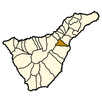
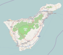
Arafo is a municipality located on the southeastern part of Tenerife, one of the amazing Canary Islands. It's part of the province of Santa Cruz de Tenerife in Spain. The main town of Arafo is about 5 kilometers (3 miles) west of the coastal town of Candelaria. It's also around 22 kilometers (14 miles) southwest of Santa Cruz de Tenerife, which is the capital city of the province.
Exploring Arafo's Location and Travel
Arafo is easy to reach thanks to the TF-1 motorway. This important road passes through the eastern side of the municipality. This makes it simple for people to travel to and from Arafo. The town itself sits at an elevation of 470 meters (1,542 feet) above sea level.
A Look at Arafo's Population Over Time
The number of people living in Arafo has changed over the years. Here's a quick look at how the population has grown:
| Year | Population |
|---|---|
| 1991 | 4,200 |
| 1996 | 4,667 |
| 2001 | 4,995 |
| 2002 | 5,156 |
| 2003 | 5,122 |
| 2004 | 5,256 |
| 2005 | 5,276 |
| 2009 | 5,502 |
As you can see, Arafo has steadily grown in population. In 2018, about 5,562 people lived there. This shows it's a growing community on the island of Tenerife.
See also
 In Spanish: Arafo para niños
 | James B. Knighten |
 | Azellia White |
 | Willa Brown |


