Aramoana facts for kids
Quick facts for kids
Aramoana
|
|
|---|---|
|
Rural settlement
|
|

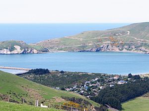
Looking east across the mouth of Otago Harbour; Aramoana settlement to the lower right
|
|
| Country | New Zealand |
| Island | South Island |
| Region | Otago |
| City | Dunedin |
| Community board | West Harbour Community Board |
| Electorates |
|
| Area | |
| • Total | 0.49 km2 (0.19 sq mi) |
| Population
(June 2023)
|
|
| • Total | 130 |
| • Density | 265/km2 (690/sq mi) |
| Time zone | UTC+12 (NZST) |
| • Summer (DST) | UTC+13 (NZDT) |
| Area code | 03 |
| Local iwi | Ngāi Tahu |
Aramoana is a small town on the coast of New Zealand's South Island. It is located about 27 kilometers north of the city of Dunedin. The name Aramoana comes from the Māori language and means "pathway of the sea".
This settlement was started in the 1880s by the Otago Harbour Board. It began as a pilot station, which is a place where special boat pilots help ships safely enter and leave the Otago Harbour. Over time, Aramoana grew into a small farming village. In the 1950s, it became a popular spot for beach holidays and country living. This was partly because a long wall, called a mole, was built to stop sand from blocking the harbour entrance.
Aramoana is also known for a very sad event that happened on November 13 and 14, 1990. A monument stands there to remember the people who lost their lives during this tragic incident.
Contents
Exploring Aramoana's Location and Nature
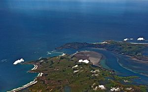
Aramoana sits on a sandy strip of land called a spit. This spit is right at the mouth of the Otago Harbour, across from the end of the Otago Peninsula.
What is the Aramoana Mole?
A key feature of Aramoana is the Aramoana mole. This is a man-made wall that stretches 1200 meters into the ocean. It helps keep the main channel of the harbour clear for ships. The mole was originally planned to be even longer, but it was not possible to extend it further due to ocean currents and building challenges.
Wildlife and Beaches of Aramoana
To the southwest of the town, there are large, salty mudflats. These mudflats stretch from the Aramoana Spit along the harbour to the town of Te Ngaru. This area is a protected Wildlife Sanctuary. It is home to many different plants and animals, both native to New Zealand and from other parts of the world.
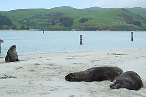
On the other side of the spit, you'll find a wide beach. This beach is divided by the Aramoana Mole. The beach and sand dunes to the east are called Shelly Beach. The beach to the west is known as Big Beach and is over two kilometers long. Along Big Beach, there are steep rock faces that meet the water. These rocks are often used by local climbers for practice. You might also see seals relaxing in the sun on the rocks of the spit. People who enjoy Land yachting often use Big Beach, especially when the wind is blowing from the northeast.
Aramoana's Population and Community
Aramoana is officially described as a rural settlement. It covers a small area of about 0.49 square kilometers. In 2018, its estimated population was 111 people. This means there are about 227 people living in each square kilometer.
How Aramoana's Population Has Changed
The number of people living in Aramoana has grown over the years.
- In 2006, there were 78 residents.
- By 2013, the population increased to 87.
- In 2018, it reached 111 people.
This shows a steady increase in the number of people choosing to live in Aramoana.
Who Lives in Aramoana?
According to the 2018 census, Aramoana had 54 households. There were more males (69) than females (42). The average age of residents was 52.2 years. About 13.5% of the population was under 15 years old. Most residents (97.3%) identified as European/Pākehā. A small number (2.7%) identified as Māori.
When asked about religion, most people (59.5%) said they had no religion. About 21.6% were Christian.
Many residents had higher education, with 21 people (21.9%) having a bachelor's degree or higher. The average income was $29,500. Most adults (53.1%) worked full-time.
The "Save Aramoana" Campaign

In the late 1970s, there was a plan to build a large aluminium smelter in Aramoana. An aluminium smelter is a factory that makes aluminum metal. This plan was put forward by a group of companies from New Zealand, Australia, and Switzerland. New Zealand already had one aluminium smelter operating at Tiwai Point.
Why People Opposed the Smelter
Many people were worried about the impact a large factory would have on Aramoana's natural environment and quiet community. Because of these concerns, the "Save Aramoana Campaign" was started in 1974.
Leaders of this campaign included three psychologists from Otago: Peter Bradshaw, Jules Older, and Richard Thomson. Many artists and performers from the Otago region also helped the campaign. Their efforts were successful, and the plan to build the smelter in Aramoana was stopped.
Aramoana's Tragic Event
Aramoana is known for a very sad event that took place on November 13 and 14, 1990. During this time, a resident caused a tragic incident where 13 people lost their lives.
Remembering the Victims
Today, a monument stands on the sand dunes near the Aramoana Mole. This monument is a special place to remember the 13 people who died during this event.
In 2006, a New Zealand director named Robert Sarkies made a film about the events. The movie is called Out of the Blue.


