Arauca River facts for kids
Quick facts for kids Arauca River |
|
|---|---|

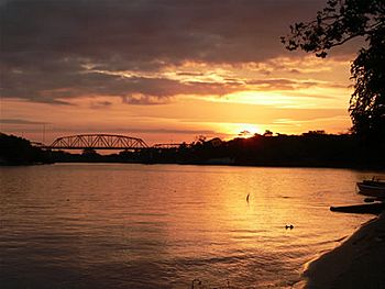
The Arauca at sunset with the Jose Antonio Paez bridge, near the city of Arauca
|
|
| Lua error in Module:Location_map at line 420: attempt to index field 'wikibase' (a nil value).
Location of mouth in Venezuela
|
|
| Countries | |
| Physical characteristics | |
| Main source | el Páramo del Almorzadero 4,000 m (13,000 ft) |
| River mouth | flows into the Orinoco |
| Length | 1,050 km (650 mi) |
The Arauca River (called Río Arauca in Spanish) is a long river in South America. It starts high up in the Andes Mountains in Colombia. From there, it flows all the way to the Orinoco River in Venezuela. For some of its journey, the Arauca River forms the natural border between Colombia and Venezuela. Important cities along its banks include Arauca in Colombia and El Amparo in Venezuela.
Contents
The River's Journey
The Arauca River is like many rivers that flow east across the Llanos Orientales. The Llanos Orientales are wide, flat plains in Colombia and Venezuela. The river begins as a fast mountain stream. As it moves across the plains, it becomes wider and slower.
Where the River Starts
The Arauca River begins very high in the Andes Mountains. It starts in a place called the Páramo del Almorzadero. This area is over 4,000 metres (13,000 ft) above sea level. At first, the river is called the Chitagá. It gets more water from smaller streams like the Carabo and the Cacota. Then, it twists and turns towards the east. It joins with the Culaga and the Bochaga rivers. After these join, its name changes to the Margua. Later, the Negro, the Colorado, and the San Lorenzo rivers also flow into it.
Changing Names and Borders
More water comes into the river from the right side. These are the Cubugón and the Cobar rivers, which flow from the Sierra Nevada de Chita mountains. The Tunebo people, who are local Indigenous people, call this part of the river the Sarare.
As the river flows into a flat area, it splits into different paths. This forms an area like Charo Island. The river then becomes the border between Colombia and Venezuela. It marks the border for about 296 kilometres (184 mi). On the right side, the Royata, Bojabá, and Banadía rivers join it. On the left side, the Cutufí river flows in.
The Arauca's Name
From this point on, the river is called the Arauca. This name honors the Araucana tribe. This tribe used to live in the mountains near the river's upper parts. They were part of the large Arawak family.
Now, the river flows through the savannas of the Llanos Orientales. Here, it often becomes a "braided river." This means the main river splits into many smaller channels that weave together. One example of these smaller channels is called Agua Limón.
River Travel
Many of these smaller channels are used for transportation. People use them to travel by boat from the town of Arauca all the way to where the river meets the Orinoco River. About 80 percent of the Arauca River's path can be traveled by small boats.
See also
 In Spanish: Río Arauca para niños
 | Kyle Baker |
 | Joseph Yoakum |
 | Laura Wheeler Waring |
 | Henry Ossawa Tanner |

