Ardmore Airport (New Zealand) facts for kids
Quick facts for kids
Ardmore Airport
|
|||||||||||||||||||
|---|---|---|---|---|---|---|---|---|---|---|---|---|---|---|---|---|---|---|---|
 |
|||||||||||||||||||
| Summary | |||||||||||||||||||
| Airport type | Public | ||||||||||||||||||
| Owner | Ardmore Airport Ltd | ||||||||||||||||||
| Operator | New Zealand Civil Aviation Authority | ||||||||||||||||||
| Location | Auckland | ||||||||||||||||||
| Elevation AMSL | 111 ft / 34 m | ||||||||||||||||||
| Coordinates | 37°01′47″S 174°58′24″E / 37.02972°S 174.97333°E | ||||||||||||||||||
| Runway | |||||||||||||||||||
|
|||||||||||||||||||
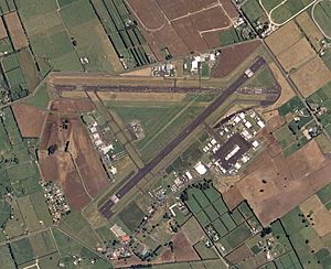
Ardmore Airport (IATA: AMZ, ICAO: NZAR) is a busy airport located about 5.5 kilometers (3 nautical miles) southeast of Manurewa in Auckland, New Zealand. It is known as one of New Zealand's most active airfields for general aviation. This means it is mostly used by smaller private planes, flying schools, and classic aircraft.
Contents
The Story of Ardmore Airport
Ardmore Airport was built during World War II by American forces who were based in Auckland. It was originally planned to be a base for large B-17 Flying Fortress bombers. However, the war changed direction, so it was never used for that purpose.
Instead, the RNZAF (Royal New Zealand Air Force) used Ardmore. They flew Corsair fighter planes from here. After the war, the RNZAF moved all its Auckland operations to Whenuapai Airport. For many years after the war, until the mid-1970s, the land was used for a teacher training college and the Auckland University School of Engineering.
Ardmore's Racing Days: The New Zealand Grand Prix
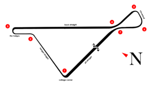
From 1954 to 1962, the Ardmore airfield became a famous race track. It hosted the exciting New Zealand Grand Prix. The race circuit was about 2 kilometers (2 miles) long and used the airport's two paved runways.
Many people came to watch these races. In 1954 and 1955, about 70,000 spectators attended the event. Eventually, local authorities decided to open the airport more fully for general aviation. Because of this, the Grand Prix moved to Pukekohe, which was a new, specially built race track.
Ardmore Airport Today
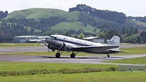
Today, Ardmore Airport is one of New Zealand's busiest airfields for general aviation. This means it is a hub for smaller aircraft, not large passenger jets. You will mostly see small private planes here. It is also home to the New Zealand Warbirds Association. They keep and fly classic aircraft from past wars.
Many different aviation businesses operate at Ardmore. These include several flying schools where people learn to fly. There are also companies that do aircraft maintenance, provide fuel, and restore old planes. The airport buildings are located around the different parking areas for planes.
A control tower stands in the middle of the airfield. However, it is no longer used for controlling air traffic. Instead, it provides a special radio service called UNICOM. This service helps pilots by giving them information about the airport.
How Ardmore Airport Operates
Ardmore has several runways for planes to take off and land. It has one paved runway and two grass runways. There used to be another paved runway, but it is now used as a taxiway for planes to move around.
Pilots flying fixed-wing aircraft (regular planes) usually fly in a circuit around the airport at 1,100 feet (335 meters). Helicopters fly at a lower circuit height of 800 feet (244 meters). For some runways, pilots turn right in the circuit, and for others, they turn left.
The airport uses a special GPS system called R-NAV for planes arriving. Ardmore is an "uncontrolled" airport. This means there is no air traffic controller giving specific instructions for every takeoff and landing. Instead, it is in a "Mandatory Broadcast Zone" (MBZ). Pilots must announce their positions and intentions on the radio. The Ardmore Unicom service monitors this airspace during daylight hours to help pilots. Ardmore Airport is located to the southeast of Auckland International Airport's airspace.
See also
- List of airports in New Zealand
- List of airlines of New Zealand
- Transport in New Zealand
 | Ernest Everett Just |
 | Mary Jackson |
 | Emmett Chappelle |
 | Marie Maynard Daly |


