Arendtsville, Pennsylvania facts for kids
Quick facts for kids
Arendtsville, Pennsylvania
|
|
|---|---|
|
Borough
|
|

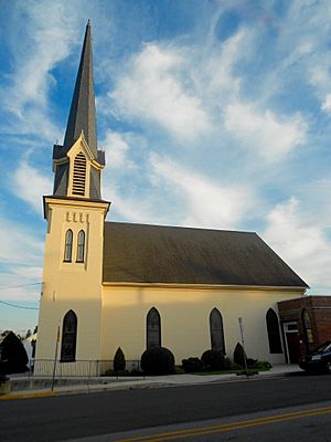
Zion UCC Church
|
|

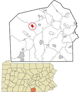
Location in Adams County and the U.S. state of Pennsylvania.
|
|
| Country | United States |
| State | Pennsylvania |
| County | Adams |
| Settled | 1810 |
| Incorporated | 1896 |
| Government | |
| • Type | Borough Council |
| Area | |
| • Total | 0.80 sq mi (2.07 km2) |
| • Land | 0.80 sq mi (2.07 km2) |
| • Water | 0.00 sq mi (0.00 km2) |
| Elevation | 702 ft (214 m) |
| Population
(2020)
|
|
| • Total | 867 |
| • Density | 1,082.40/sq mi (418.04/km2) |
| Time zone | UTC-5 (Eastern (EST)) |
| • Summer (DST) | UTC-4 (EDT) |
| Zip Code |
17303
|
| Area code(s) | 717 |
| FIPS code | 42-02928 |
| Website | http://www.arendtsville.org/ |
Arendtsville is a small town, also called a borough, located in Adams County, Pennsylvania, in the United States. It sits along Pennsylvania Route 234. This town is famous for its yearly Apple Harvest Festival, which happens every fall. In 2020, about 867 people lived here.
Contents
History of Arendtsville
Arendtsville got its name from an early settler. His name was John Arendt. The town was settled in 1810. Later, it officially became a borough in 1896.
Geography and Location
Arendtsville is located at 39°55′28″N 77°17′50″W / 39.92444°N 77.29722°W. The U.S. Census Bureau says the borough covers about 0.8 square miles (2.07 square kilometers). All of this area is land.
The town is close to South Mountain. This mountain is part of the Blue Ridge Mountain Range, extending north.
People of Arendtsville
| Historical population | |||
|---|---|---|---|
| Census | Pop. | %± | |
| 1880 | 248 | — | |
| 1900 | 393 | — | |
| 1910 | 383 | −2.5% | |
| 1920 | 358 | −6.5% | |
| 1930 | 338 | −5.6% | |
| 1940 | 381 | 12.7% | |
| 1950 | 409 | 7.3% | |
| 1960 | 588 | 43.8% | |
| 1970 | 589 | 0.2% | |
| 1980 | 600 | 1.9% | |
| 1990 | 693 | 15.5% | |
| 2000 | 848 | 22.4% | |
| 2010 | 952 | 12.3% | |
| 2020 | 867 | −8.9% | |
| Sources: | |||
In 2000, there were 848 people living in Arendtsville. These people lived in 329 households. About 242 of these were families. The population density was about 1,221 people per square mile.
Many households (39.2%) had children under 18 living there. Most households (59.3%) were married couples living together. About 22.8% of all households were people living alone.
The average age of people in the borough was 34 years old. About 29.5% of the population was under 18. Also, 15.4% of the people were 65 years old or older.
Education in Arendtsville
The Upper Adams School District serves the borough of Arendtsville. The district's intermediate school, Upper Adams Intermediate School, is located right in Arendtsville.
See also
 In Spanish: Arendtsville para niños
 | Victor J. Glover |
 | Yvonne Cagle |
 | Jeanette Epps |
 | Bernard A. Harris Jr. |


