Ariton, Alabama facts for kids
Quick facts for kids
Ariton, Alabama
|
|
|---|---|

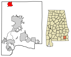
Location of Ariton in Dale County, Alabama
|
|
| Country | United States |
| State | Alabama |
| County | Dale |
| Area | |
| • Total | 5.09 sq mi (13.18 km2) |
| • Land | 5.09 sq mi (13.18 km2) |
| • Water | 0.00 sq mi (0.00 km2) |
| Elevation | 459 ft (140 m) |
| Population
(2020)
|
|
| • Total | 662 |
| • Density | 130.06/sq mi (50.22/km2) |
| Time zone | UTC-6 (Central (CST)) |
| • Summer (DST) | UTC-5 (CDT) |
| ZIP code |
36311
|
| Area code(s) | 334 |
| FIPS code | 01-02428 |
| GNIS feature ID | 0151663 |
Ariton is a small town in Dale County, Alabama, United States. In 2020, about 662 people lived there. Ariton became an official town in April 1906. Its name is a mix of two older town names: Ariosto and Charlton.
Ariton is also part of the larger Ozark area, which is a group of towns that are close together.
Contents
Where is Ariton Located?
Ariton is in the northwestern part of Dale County. You can find it at 31°35′54″N 85°43′8″W / 31.59833°N 85.71889°W. Two main roads, Alabama State Routes 51 and 123, run through the middle of town. These roads are known as Main Street.
- AL 51 goes northeast for about 11 miles to Clio.
- AL 51 also goes southwest for about 3.5 miles to U.S. Route 231.
- AL 123 goes west for about 3.5 miles to US 231.
- AL 123 also goes southeast for about 12 miles to Ozark, which is the main city in Dale County.
The town covers an area of about 5.09 square miles (13.2 square kilometers), and all of it is land.
How Many People Live in Ariton?
Ariton first appeared in the U.S. Census in 1910 as an official town.
Population Changes Over Time
| Historical population | |||
|---|---|---|---|
| Census | Pop. | %± | |
| 1910 | 431 | — | |
| 1920 | 625 | 45.0% | |
| 1930 | 611 | −2.2% | |
| 1940 | 561 | −8.2% | |
| 1950 | 620 | 10.5% | |
| 1960 | 687 | 10.8% | |
| 1970 | 643 | −6.4% | |
| 1980 | 844 | 31.3% | |
| 1990 | 743 | −12.0% | |
| 2000 | 772 | 3.9% | |
| 2010 | 764 | −1.0% | |
| 2020 | 662 | −13.4% | |
| U.S. Decennial Census | |||
The population of Ariton has changed over the years. In 1980, it reached its highest population with 844 people. By 2020, the population was 662.
Who Lives in Ariton?
In 2020, there were 662 people living in Ariton. These people lived in 272 households, which are like homes or families. Out of these, 182 were families.
Most people in Ariton are White (about 65.71%). About 21% of the people are Black or African American. There are also smaller groups of Native American, Asian, and people of mixed races. About 8.91% of the people in Ariton are Hispanic or Latino.
Ariton's Climate
Ariton has a type of weather called a humid subtropical climate. This means the summers are hot and humid, while the winters are usually mild to cool. On climate maps, this is often shown as "Cfa."
| Climate data for Ariton, Alabama | |||||||||||||
|---|---|---|---|---|---|---|---|---|---|---|---|---|---|
| Month | Jan | Feb | Mar | Apr | May | Jun | Jul | Aug | Sep | Oct | Nov | Dec | Year |
| Mean daily maximum °C (°F) | 16 (61) |
18 (64) |
22 (71) |
26 (79) |
29 (85) |
33 (91) |
33 (91) |
33 (91) |
31 (88) |
27 (80) |
21 (70) |
17 (62) |
26 (78) |
| Mean daily minimum °C (°F) | 4 (39) |
5 (41) |
9 (48) |
12 (54) |
17 (62) |
20 (68) |
21 (70) |
21 (70) |
19 (66) |
13 (56) |
8 (46) |
5 (41) |
13 (55) |
| Average precipitation mm (inches) | 120 (4.6) |
130 (5) |
140 (5.7) |
120 (4.6) |
94 (3.7) |
120 (4.6) |
160 (6.3) |
120 (4.9) |
110 (4.3) |
58 (2.3) |
81 (3.2) |
120 (4.9) |
1,370 (54.1) |
| Source: Weatherbase | |||||||||||||
Famous People From Ariton
Ariton has been home to some notable people:
- Eunice Hutto Morelock was one of the first teachers at Bob Jones College. She might have been the first woman to be a chief academic officer at a college that allowed both boys and girls.
- Willie Mae "Big Mama" Thornton was a famous American rhythm and blues singer and songwriter.
See also
 In Spanish: Ariton para niños
 | Sharif Bey |
 | Hale Woodruff |
 | Richmond Barthé |
 | Purvis Young |

