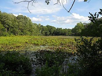
Artichoke River (Massachusetts) facts for kids
Quick facts for kids Artichoke River |
|
|---|---|

Lower Artichoke River
|
|
| Country | US |
| Physical characteristics | |
| Main source | West Newbury, Massachusetts 20 feet (6 m) at West Newbury, Massachusetts |
| River mouth | Merrimack River |
| Length | 1.2 miles (2 km) |
| Basin features | |
| Basin size | 3.5 square miles (9.1 km2) |
The Artichoke River is a small but important river in Massachusetts, United States. It is about 1.2 miles (1.9 kilometers) long. This river flows into the larger Merrimack River. It is located in Essex County, Massachusetts. The river forms a natural border between the towns of West Newbury and Newburyport.
Contents
Discover the Artichoke River
The Artichoke River might be short, but it plays a big role. It helps supply water to nearby communities.
Where is the Artichoke River?
The river starts in West Newbury, Massachusetts. It then flows generally north. It marks the edge between West Newbury and Newburyport. Finally, it joins the Merrimack River.
Why is the River Important?
Even though it is a short river, the Artichoke River has three dams. These dams help control the water flow. They also create two large ponds, called the Upper and Lower Artichoke reservoirs. These reservoirs are like big storage tanks for water. They provide drinking water for local towns. The dams are named Emory Lane Dam, Lower Artichoke Dam, and Upper Artichoke Dam.
What's in a Name?
The river got its interesting name from a plant. This plant is called the Jerusalem artichoke. It is not a true artichoke, but a type of sunflower. Native Americans and early settlers used to harvest this plant near the river. That is how the river got its unique name.
 | Toni Morrison |
 | Barack Obama |
 | Martin Luther King Jr. |
 | Ralph Bunche |

