
Ashaway, Rhode Island facts for kids
Quick facts for kids
Ashaway, Rhode Island
|
|
|---|---|
|
CDP
|
|

First Seventh Day Baptist Church of Hopkinton
|
|

Ashaway, Rhode Island
Location in Rhode Island
|
|
| State | Rhode Island |
| County | Washington |
| Area | |
| • Total | 2.42 sq mi (6.26 km2) |
| • Land | 2.37 sq mi (6.15 km2) |
| • Water | 0.04 sq mi (0.11 km2) |
| Elevation | 62 ft (19 m) |
| Population
(2020)
|
|
| • Total | 1,501 |
| • Density | 632.27/sq mi (244.11/km2) |
| Time zone | UTC−5 (Eastern (EST)) |
| • Summer (DST) | UTC−4 (EDT) |
| ZIP Code |
02804
|
| Area code(s) | 401 |
| FIPS code | 44-03520 |
| GNIS feature ID | 1217657 |
Ashaway (pronounced ASH-uh-way) is a small village in Hopkinton, Rhode Island, USA. It's also known as a "census-designated place" (CDP). This means it's a special area defined by the government for counting people.
Ashaway is one of the main villages in Hopkinton. However, it is smaller than Hope Valley, another important village nearby. In 2020, about 1,501 people lived in Ashaway.
The name Ashaway comes from the local Native American languages, Niantic and Mohegan. The river that flows through the village was called Ashawague or Ashawaug. This name means "land in the middle" or "land between."
Contents
Where is Ashaway Located?
Ashaway is found at these coordinates: 41.423004 degrees North and -71.788839 degrees West. It's in the state of Rhode Island.
How Big is Ashaway?
According to the United States Census Bureau, Ashaway covers a total area of about 6.2 square kilometers (2.4 square miles). Most of this area, about 6.15 square kilometers (2.37 square miles), is land. A small part, about 0.11 square kilometers (0.04 square miles), is water.
Who Lives in Ashaway?
| Historical population | |||
|---|---|---|---|
| Census | Pop. | %± | |
| 2020 | 1,501 | — | |
| U.S. Decennial Census | |||
People in Ashaway in 2020
The 2020 United States census counted 1,501 people living in Ashaway. There were 584 households, which are groups of people living together. About 430 of these were families.
Most people in Ashaway, about 94%, are white or European American. There are also smaller groups of African American, Native American, and Asian residents. About 2.2% of the population is Hispanic or Latino.
Many households, about 28.4%, had children under 18 living there. More than half, 52.7%, were married couples. About 24.5% of households were single people living alone.
The average age of people in Ashaway was about 43.3 years old. About 22.2% of the population was under 18.
People in Ashaway in 2010
In the 2010 census, there were 1,485 people living in Ashaway. There were 566 households. Most people, about 94.14%, were white.
About 33.7% of households had children under 18. More than half, 54.2%, were married couples living together.
The average age of people in Ashaway was about 42.3 years old. About 19% of the population was under 18.
Media in Ashaway
Ashaway is home to a radio station called WSUB-LP. You can listen to it at 96.7 FM, and it's also known as "The Buzz." The station's antenna is on top of an old smokestack. The Federal Communications Commission (FCC) officially lists Ashaway as the station's home city. The Buzz Alternative Radio Foundation, Inc. owns and runs WSUB-LP.
Images for kids
-
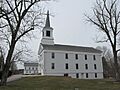
The First Seventh Day Baptist Church of Hopkinton in Ashaway.
See also
 In Spanish: Ashaway para niños
