Ashberham River facts for kids
Quick facts for kids Ashberham River |
|
|---|---|

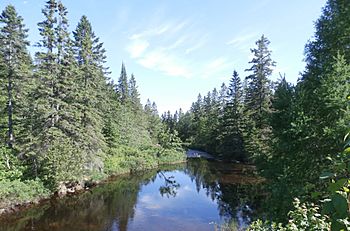
Ashberham River downstream from Chemin du Petit-Lac-Saint-François towards Grand Lac Saint-François.
|
|
| Native name | Rivière Ashberham |
| Country | Canada |
| Province | Quebec |
| Region | Chaudière-Appalaches |
| MRC | Les Appalaches Regional County Municipality |
| Municipality | Saint-Joseph-de-Coleraine |
| Physical characteristics | |
| Main source | Moutain streams Saint-Joseph-de-Coleraine 408 m (1,339 ft) 46°03′54″N 71°18′47″W / 46.064937°N 71.313184°W |
| River mouth | Grand lac Saint François Saint-Joseph-de-Coleraine 288 m (945 ft) 45°58′33″N 71°15′08″W / 45.97583°N 71.25222°W |
| Length | 20.0 km (12.4 mi) |
| Basin features | |
| Progression | Saint-François River, St. Lawrence River |
| Tributaries |
|
The Ashberham River (called rivière Ashberham in French) is a river in Quebec, Canada. It flows into Grand lac Saint François, which is the main lake at the start of the Saint-François River. The Ashberham River flows through the area of Saint-Joseph-de-Coleraine, a town in the Les Appalaches Regional County Municipality. This region is part of Chaudière-Appalaches, located on the South Shore of the St. Lawrence River.
Contents
Where is the Ashberham River?
The Ashberham River is in Quebec, Canada. It starts in the mountains and flows into a large lake.
River's Neighbors
The main areas around the Ashberham River are:
- North: Bécancour River and Bécancour Lake
- East: Rivière de l'Or
- South: Grand lac Saint François
- West: Lake Noir, Bisby River, and Bécancour River
Where the River Starts
The Ashberham River begins on the south side of the Collines de Bécancour. This is southwest of the Thetford Mines airport. It starts from small mountain streams.
The River's Journey
From its source, the river flows for about 8.3 kilometres (5.2 mi) (5.2 miles). It first goes southeast, then south, and finally southwest. It then empties into the north shore of Caribou Lake.
Caribou Lake is about 2.2 kilometres (1.4 mi) (1.4 miles) long and sits at an altitude of 331 meters (1,086 feet). The river flows through this lake, continuing southwest. This lake is surrounded by mountains and hills.
After Caribou Lake, the Ashberham River flows for about 5.9 kilometres (3.7 mi) (3.7 miles) south, then southeast. Here, Beebe Creek joins it from the north. The river then flows 0.8 kilometres (0.50 mi) (0.5 miles) east, passing under a road bridge. It then reaches the west shore of Petit lac Saint-François (Ashberham). Many chalets are built around this lake.
The river crosses "Petit lac Saint-François" for about 1.5 kilometres (0.93 mi) (0.9 miles) towards the southwest. It then flows another 1.3 kilometres (0.81 mi) (0.8 miles) south to its end.
Where the River Ends
The Ashberham River flows into the north shore of Grand lac Saint François. This is about 3.3 kilometres (2.1 mi) (2.1 miles) northeast of the Jules-Allard dam. It is also about 2.8 kilometres (1.7 mi) (1.7 miles) southwest of where the Rivière de l'Or enters the lake.
Name of the River
The name "Rivière Ashberham" was officially recorded on December 5, 1968. This was done by the Commission de toponymie du Québec, which is the official body for naming places in Quebec.
 | Janet Taylor Pickett |
 | Synthia Saint James |
 | Howardena Pindell |
 | Faith Ringgold |

