Ashland, Natchitoches Parish, Louisiana facts for kids
Quick facts for kids
Ashland, Louisiana
|
|
|---|---|
| Village of Ashland | |

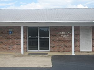
Ashland Village Hall is located next to the United States Post Office building
|
|

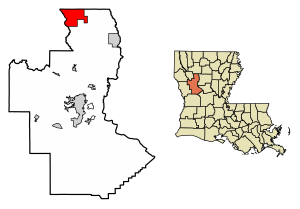
Location of Ashland in Natchitoches Parish, Louisiana.
|
|
| Country | United States |
| State | Louisiana |
| Parish | Natchitoches |
| Incorporated | 1963 |
| Area | |
| • Total | 27.15 sq mi (70.31 km2) |
| • Land | 26.99 sq mi (69.90 km2) |
| • Water | 0.16 sq mi (0.42 km2) |
| Area rank | NC: 1st LA: 11th |
| Elevation | 226 ft (69 m) |
| Population
(2020)
|
|
| • Total | 194 |
| • Rank | NC: 7th |
| • Density | 7.19/sq mi (2.78/km2) |
| Time zone | UTC−6 (CST) |
| • Summer (DST) | UTC−5 (CDT) |
| Area code | 318 |
| FIPS code | 22-03145 |
| GNIS feature ID | 2407410 |
Ashland is a small village located in the northern part of Natchitoches Parish, Louisiana, in the United States. A few homes and a store are also found in the nearby Bienville Parish.
In 2000, about 291 people lived in Ashland. By 2010, the population had gone down to 269. The village is part of the larger Natchitoches area.
Contents
Exploring Ashland's Location and Size
Ashland is a small place. It covers about 27.1 square miles (about 70 square kilometers). Most of this area is land, with a very small part being water.
Understanding Ashland's Climate
Ashland has a humid subtropical climate. This means it has fairly high temperatures all year round. It also gets a good amount of rain spread out through the year.
| Climate data for Ashland, Louisiana (1991–2020 normals, extremes 1954–2014) | |||||||||||||
|---|---|---|---|---|---|---|---|---|---|---|---|---|---|
| Month | Jan | Feb | Mar | Apr | May | Jun | Jul | Aug | Sep | Oct | Nov | Dec | Year |
| Record high °F (°C) | 82 (28) |
87 (31) |
89 (32) |
92 (33) |
97 (36) |
103 (39) |
107 (42) |
108 (42) |
110 (43) |
97 (36) |
90 (32) |
84 (29) |
110 (43) |
| Mean daily maximum °F (°C) | 57.7 (14.3) |
61.9 (16.6) |
69.2 (20.7) |
76.1 (24.5) |
82.6 (28.1) |
89.2 (31.8) |
92.0 (33.3) |
93.0 (33.9) |
88.0 (31.1) |
78.3 (25.7) |
68.3 (20.2) |
59.4 (15.2) |
76.3 (24.6) |
| Daily mean °F (°C) | 45.9 (7.7) |
49.7 (9.8) |
57.0 (13.9) |
63.7 (17.6) |
71.6 (22.0) |
78.3 (25.7) |
81.3 (27.4) |
81.2 (27.3) |
75.7 (24.3) |
65.0 (18.3) |
55.2 (12.9) |
47.8 (8.8) |
64.4 (18.0) |
| Mean daily minimum °F (°C) | 34.2 (1.2) |
37.5 (3.1) |
44.7 (7.1) |
51.3 (10.7) |
60.7 (15.9) |
67.4 (19.7) |
70.5 (21.4) |
69.5 (20.8) |
63.4 (17.4) |
51.7 (10.9) |
42.1 (5.6) |
36.1 (2.3) |
52.4 (11.3) |
| Record low °F (°C) | −5 (−21) |
10 (−12) |
11 (−12) |
24 (−4) |
32 (0) |
45 (7) |
53 (12) |
48 (9) |
34 (1) |
24 (−4) |
14 (−10) |
2 (−17) |
−5 (−21) |
| Average precipitation inches (mm) | 5.38 (137) |
5.24 (133) |
5.56 (141) |
5.25 (133) |
4.63 (118) |
4.00 (102) |
3.81 (97) |
3.18 (81) |
3.92 (100) |
4.56 (116) |
4.99 (127) |
6.18 (157) |
56.70 (1,440) |
| Average snowfall inches (cm) | 0.1 (0.25) |
0.3 (0.76) |
0.0 (0.0) |
0.0 (0.0) |
0.0 (0.0) |
0.0 (0.0) |
0.0 (0.0) |
0.0 (0.0) |
0.0 (0.0) |
0.0 (0.0) |
0.0 (0.0) |
0.1 (0.25) |
0.5 (1.3) |
| Average precipitation days (≥ 0.01 in) | 8.8 | 8.2 | 8.4 | 6.7 | 6.7 | 7.2 | 7.7 | 6.2 | 6.2 | 6.6 | 7.3 | 8.3 | 88.3 |
| Average snowy days (≥ 0.1 in) | 0.1 | 0.1 | 0.0 | 0.0 | 0.0 | 0.0 | 0.0 | 0.0 | 0.0 | 0.0 | 0.0 | 0.2 | 0.4 |
| Source: NOAA | |||||||||||||
Who Lives in Ashland?
The number of people living in Ashland has changed over the years.
- In 1970, there were 211 residents.
- By 1980, the population grew to 289.
- It stayed at 289 in 1990.
- In 2000, it slightly increased to 291 people.
- By 2010, the population dropped to 269.
- The most recent count in 2020 showed 194 people living in the village.
In 2020, there were 194 people living in Ashland. These people lived in 77 households, which means 77 different groups of people or families. Out of these, 57 were families. Most residents were White (about 83%), with African American people making up about 11%. A small number of people were Native American or of mixed heritage. About 3% of the population was Hispanic or Latino.
See also
 In Spanish: Ashland (Luisiana) para niños
 | Jewel Prestage |
 | Ella Baker |
 | Fannie Lou Hamer |

