Asiru Phat'jata facts for kids
Quick facts for kids Asiru Phat'jata |
|
|---|---|

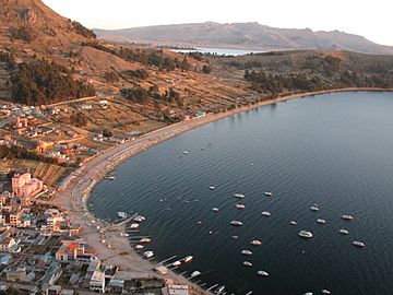
View of Copacabana with Asiru Phat'jata in the background (on the right)
|
|
| Highest point | |
| Elevation | 3,895 m (12,779 ft) |
| Geography | |
| Location | Peru, Puno Region |
Asiru Phat'jata is a hill located in Peru. Its name comes from the Aymara language. Asiru means "snake" and phat'jaña means "to split in half." So, Asiru Phat'jata means "split snake."
This hill stands about 3,895 meters (12,779 feet) high. It is found in the Puno Region of Peru, specifically in the Yunguyo Province and Yunguyo District. Asiru Phat'jata is very close to the famous Lake Titicaca. You can see it near the road that connects the towns of Yunguyo and Puno. It is located south of a village also called Asiru Phat'jata and north of a mountain named Qhapiya.
Discovering Ancient History
On Asiru Phat'jata hill, there is an important archaeological area. This means it is a special place where people have found old things from the past. These discoveries help us learn about ancient cultures and how people lived long ago.
The National Institute of Culture in Peru has officially recognized this site. They declared it a National Cultural Heritage (Patrimonio Cultural). This means it is a very important historical place for Peru, and it is protected by the country.
Gallery
-
Satellite view of Wiñaymarka Lake, the southern sub-basin of Lake Titicaca, and the extinct volcano Qhapiya (on the left). Asiru Phat'jata is visible north of Qhapiya.
See also
 In Spanish: Asiru Phatjata para niños
 | Aurelia Browder |
 | Nannie Helen Burroughs |
 | Michelle Alexander |


