Aspe peak facts for kids
Quick facts for kids Aspe |
|
|---|---|
| Pico de la Garganta de Aísa | |

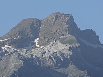
Aspe from Aísa
|
|
| Highest point | |
| Elevation | 2,645 m (8,678 ft) |
| Listing | Mountains of Spain |
| Naming | |
| Language of name | Spanish |
| Geography | |
| Location | Province of Huesca, Spain |
| Parent range | Pyrenees |
| Climbing | |
| First ascent | Unknown |
| Easiest route | From Candanchú |
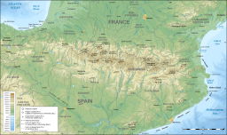
Aspe peak (also known as Pico de la Garganta de Aísa) is a tall mountain in the western Pyrenees mountain range. It is found in Huesca, Spain. This peak is on the west side of the Aragon Valley, close to the towns of Villanúa (to the south) and Canfranc (to the east). Aspe peak stands 2,645 metres (8,678 ft) AMSL (that means above mean sea level). It is connected to another peak called Zapatilla.
Contents
What Aspe Peak Overlooks
Aspe peak is a very noticeable landmark in the area. It stands high above the Spanish ski resort of Candanchú. It also overlooks the Somport pass, which is a mountain pass that forms part of the border with France. The peak is so important that it gives its name to a French river, the Gave d'Aspe, and the Aspe Valley in France.
Climbing Aspe Peak
There are different ways to climb Aspe peak. These paths are known as ascent routes. Climbing a mountain like Aspe can be a great adventure!
South-Western Route
One way to reach the top is by taking the south-western route. This path starts from the Refugio de Rigüelo. You then follow the trail to the brecha de Aspe and up the western side to the summit. This route involves climbing about 1180 metres. It usually takes around 3 hours and 20 minutes to complete.
Normal Route from Candanchú
Another common way to climb Aspe peak is from the northeast. This route starts from the Candanchú ski resort. It is often called the "normal way" because it is a popular and well-known path for climbers.
See also
 In Spanish: Pico Aspe para niños
 | Charles R. Drew |
 | Benjamin Banneker |
 | Jane C. Wright |
 | Roger Arliner Young |


