
Aspremont, Hautes-Alpes facts for kids
Quick facts for kids
Aspremont
|
|
|---|---|

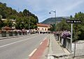
The bridge of the highway (formerly N75) over the River Buëch in Aspremont
|
|

Aspremont
Location in France

Aspremont
Location in Provence-Alpes-Côte d'Azur
|
|
| Country | France |
| Region | Provence-Alpes-Côte d'Azur |
| Department | Hautes-Alpes |
| Arrondissement | Gap |
| Canton | Serres |
| Intercommunality | Buëch Dévoluy |
| Area
1
|
18.52 km2 (7.15 sq mi) |
| Population
(Jan. 2019)
|
369 |
| • Density | 19.92/km2 (51.60/sq mi) |
| Time zone | UTC+01:00 (CET) |
| • Summer (DST) | UTC+02:00 (CEST) |
| INSEE/Postal code |
05008 /05140
|
| Elevation | 696–1,378 m (2,283–4,521 ft) (avg. 715 m or 2,346 ft) |
| 1 French Land Register data, which excludes lakes, ponds, glaciers > 1 km2 (0.386 sq mi or 247 acres) and river estuaries. | |
Aspremont is a small village, also known as a commune, located in the Hautes-Alpes department in southeastern France. It is nestled in a beautiful natural area. The village is known for its quiet charm and connection to the surrounding mountains and rivers.
Contents
About Aspremont
Aspremont is part of the Hautes-Alpes department. This area is famous for its stunning mountain landscapes. The village is a peaceful place with a small number of residents. It offers a glimpse into traditional French village life.
Where is Aspremont?
Aspremont is found in the Provence-Alpes-Côte d'Azur region of France. It is in the arrondissement of Gap. The village is also part of the canton of Serres. Its location in the River Buëch valley makes it quite scenic.
How Many People Live There?
As of January 2019, about 369 people lived in Aspremont. This makes it a very small community. The number of people living in Aspremont has stayed fairly steady over the years.
Getting Around Aspremont
Even though Aspremont is a small village, several roads pass through it. These roads connect Aspremont to other towns and areas. They are important for locals and visitors.
Main Roads
The main roads that go through Aspremont include:
- D49
- D227
- D993B
- D1075
These roads help people travel in and out of the commune. They link Aspremont to the wider region.
Images for kids
-
The bridge over the River Buëch in Aspremont.
See also
 In Spanish: Aspremont (Altos Alpes) para niños
