Atherton, Indiana facts for kids
Quick facts for kids
Atherton, Indiana
|
|
|---|---|

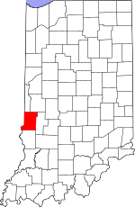
Vigo County's location in Indiana
|
|
| Country | United States |
| State | Indiana |
| County | Vigo County |
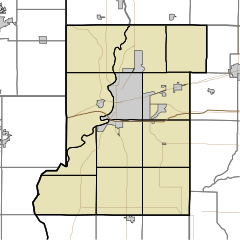
| Township | Otter Creek |
| Elevation | 528 ft (161 m) |
| Time zone | UTC-5 (Eastern (EST)) |
| • Summer (DST) | UTC-4 (EDT) |
| ZIP code |
47874
|
| Area code(s) | 765 |
| GNIS feature ID | 430321 |
Atherton is a small, unincorporated community located in Vigo County, Indiana, in the United States. Being "unincorporated" means it doesn't have its own local government like a city or town. Instead, it's governed by the county. Atherton is also part of the larger Terre Haute metropolitan area.
A Look Back at Atherton's History
Atherton was officially created on October 7, 1871. It was "laid out and platted," which means its streets and property lots were planned and drawn on a map. Newton Rogers, Sarah A. Denny, and Mary J. Rogers were the people who signed the original plan.
The northern edge of Atherton marked the border between Vigo County and Parke County. The early community grew up around its railroad station, which was an important place for travel and trade back then.
A post office was opened in Atherton in 1881. This was a vital service for sending and receiving mail before the internet and phones were common. The post office served the community for many years until it closed down in 1934.
Where is Atherton?
Atherton is located at specific geographic coordinates: 39°36′29″N 87°21′43″W / 39.60806°N 87.36194°W. This helps pinpoint its exact spot on a map. The community is situated at an elevation of 528 feet (about 161 meters) above sea level.
 | Mary Eliza Mahoney |
 | Susie King Taylor |
 | Ida Gray |
 | Eliza Ann Grier |


