Atlatlahucan facts for kids
Quick facts for kids
Atlatlahucan
|
|
|---|---|
|
Town
|
|

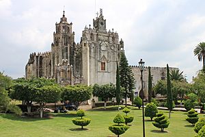
The monastery of San Mateo Atlatahucan
|
|
| Country | |
| State | Morelos |
| Elevation | 1,617 m (5,305 ft) |
| Population
(2020)
|
|
| • Total | 25,232 |
| Time zone | UTC-6 (Central Zone) |
| • Summer (DST) | UTC-5 (Central Zone) |
| Postal code |
62840
|
| Area code(s) | 735 |
Atlatlahucan is a town in the Mexican state of Morelos. Its name comes from the Nahuatl language and means "Place of red or brown water". Today, water is often kept in special cisterns called jagüeys.
Atlatlahucan is located north of Cuautla and east of Tlayacapan. It sits at an average height of 1,656 meters (5,433 ft.) above sea level. The area of the municipality is about 71 square kilometers (27.4 square miles). In 2020, the municipality of Atlatlahucan had a population of 25,232 people. The town of Atlatlahucan itself had 9,018 residents.
Contents
History of Atlatlahucan
Ancient Times and Aztec Rule
Around the year 1436, the Xochimilcas people expanded their lands to include Atlatlahucan. Later, the Aztec ruler Moctezuma Ilhuicamina also took control of Atlatlahucan. This meant the town had to pay "tribute" (a kind of tax or payment) to the Aztec empire.
Arrival of the Spanish
After the Spanish arrived and conquered the area, Atlatlahucan became part of a Spanish territory. In 1533, Augustinian friars (religious brothers) named Jerónimo de San Esteban and Jorge de Ávila came to the town. They built a church, and later, around 1570, a monastery was founded.
Becoming a Municipality
For a long time, Atlatlahucan was a smaller part of the nearby town of Tlayacapan. But on December 25, 1932, Atlatlahucan became its own independent municipality. Ignacio Bello was chosen as its first municipal president.
Recent Events
In 1964, there was an accident in the town when some fireworks exploded, causing injuries.
In 2018, Calixto Urbano Lagunas was elected as the Presidente Municipal (municipal president).
During the COVID-19 pandemic in Mexico in 2020, Atlatlahucan, like many places, saw changes. Schools and many businesses were closed for a time to help keep people safe. Local government groups helped by sending food and water to families who needed it.
Exploring Atlatlahucan's Attractions
The San Mateo Apóstol Monastery
One of the most important places to visit is the monastery of San Mateo Atlatahucan. It was founded by Fray Jorge de Avila around 1570. This monastery, along with others in the region, is part of the UNESCO World Heritage Sites. This means they are very important historical and cultural places recognized by the United Nations.
The monastery building is shaped like a rectangle. It has an open chapel with three arches. The front of the church has a simple arched doorway. Above it, there's a window and a classic clock from the late 1800s. Behind the church, there is a bell tower.
The inside of the monastery, called the cloister, is very plain and simple. This is different from the more decorated parts of the church. The main festival for St. Matthew the Apostle is celebrated on September 21.
Other Interesting Places and Festivals
Atlatlahucan has many small chapels in its neighborhoods. Some of these old chapels still stand today, like the Capilla de los Reyes (Chapel of the Three Kings) and the Capilla de la Asunción (Chapel of the Assumption).
The town also celebrates major festivals. One is Carnaval, which happens before the Christian season of Lent. Another is the Festivity of Christ Appeared, which celebrates the appearances of Jesus after his resurrection. During these festivals, you can often see the lively Dance of the Chinelos, usually with a brass band playing music.
Communities in Atlatlahucan
Atlatlahucan is the main town and the center of the municipality. Its main activities are farming and trade. It is about 30 kilometers (18.6 miles) from Cuernavaca and 91 kilometers (56.5 miles) from Mexico City.
Other important communities in the municipality include:
- Fraccionamiento Lomas de Cocoyoc, with 2,506 residents.
- Las Minas, with 2,211 residents.
- Tlaltetelco (San Miguel Tlaltetelco), with 2,098 residents.
- Colonia San Francisco, with 1,537 residents.
- San Juan Texcalpan, with 1,505 residents.
- Colonia Kilómetro 88, with 1,099 residents.
Many other parts of the municipality are used for farming.
Geography and Nature
The municipality of Atlatlahucan covers about 71 square kilometers (27.4 square miles). The land has many hills and ravines, especially in the northern and southeastern parts. About 7.4% of the area is hilly. The northern valleys make up 67% of the land, and the southern plains cover 25%.
About 3,000 hectares (7,400 acres) of the land are used for farming. Another 3,990 hectares (9,860 acres) are covered by forests.
Climate
The climate in Atlatlahucan is generally cool and mild. The average temperature throughout the year is about 20°C (68°F). The area gets about 1,005 cubic millimeters (35.6 inches) of rain each year.
Water Resources
The area has several water sources. These include the El Salto ravine, which joins the Arroyo del Bosque (stream of the woods) in Oaxtepec. There is also a ravine that flows into the Yautepec River.
Plants and Animals
The natural plant life in Atlatlahucan mainly consists of pine-oak forests and pine forests.
The animals you might find here include:
- White-tailed deer
- Raccoons
- Skunks
- Squirrels
- Volcanic mice
- Pumas or mountain lions
- Different types of birds like Moctezuma quail, mountain hen, and goldfinch
- Reptiles such as rattlesnakes, rat vipers, frogs, and lizards
See also
 In Spanish: Atlatlahucan para niños
 | Calvin Brent |
 | Walter T. Bailey |
 | Martha Cassell Thompson |
 | Alberta Jeannette Cassell |

