Auburn, Kansas facts for kids
Quick facts for kids
Auburn, Kansas
|
|
|---|---|

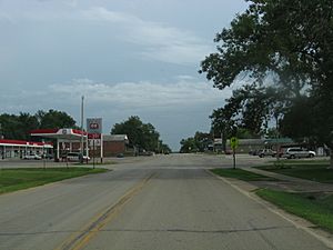
Downtown Auburn (2008)
|
|

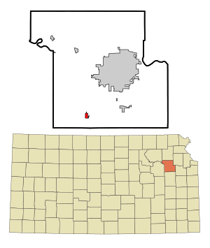
Location within Shawnee County and Kansas
|
|

|
|
| Country | United States |
| State | Kansas |
| County | Shawnee |
| Founded | 1856 |
| Incorporated | 1963 |
| Area | |
| • Total | 0.70 sq mi (1.81 km2) |
| • Land | 0.70 sq mi (1.80 km2) |
| • Water | 0.00 sq mi (0.01 km2) |
| Elevation | 1,079 ft (329 m) |
| Population
(2020)
|
|
| • Total | 1,273 |
| • Density | 1,819/sq mi (703.3/km2) |
| Time zone | UTC-6 (CST) |
| • Summer (DST) | UTC-5 (CDT) |
| ZIP code |
66402
|
| Area code | 785 |
| FIPS code | 20-03250 |
| GNIS ID | 2394025 |
Auburn is a city located in Shawnee County, Kansas, United States. In 2020, about 1,273 people lived in the city. It is a small community with a rich history.
Contents
History of Auburn
How Auburn Began
In July 1854, a man named John W. Brown explored this area. He found it perfect for a home. He traded with local Native Americans to get about 800 acres of land. Later, he went back to Missouri to tell his family and friends. Some of them came back with him.
In 1856, Mr. Brown, along with M. C. Dickey, Loring Farnsworth, and Henry Fox, set aside 320 acres for a new town. They first called it Brownville. But in 1857, they changed the name to "Auburn." This was because another town already had the name Brownville. Auburn was located on the California Road, an important travel route. Many buildings were quickly built, and the town grew fast. Two daily stage lines brought mail and people, making business good.
Early Life and Growth
Robert Simmerwell was a missionary who worked with Native Americans in the Auburn area. He had previously worked with the Pottawatomie Indians in Michigan. He taught boys and girls reading, writing, math, and practical skills. In 1854, he and his wife retired to a homestead southwest of Auburn.
In the 1850s, Auburn grew very quickly. People called it a "boom town" because it was expanding so fast. It was one of the biggest towns in Kansas at the time. Auburn almost became the state capital! However, the railroad did not come through Auburn. Instead, Topeka was chosen as the capital because it had a railroad and an important ferry crossing on the Kansas River. After this, Auburn's population became much smaller. For many years, only about 100 people lived there.
Auburn in the 20th Century
By 1912, Auburn was a small trading center. It had churches and telephone connections to nearby towns. Two mail routes started from Auburn, delivering mail to farmers. In 1910, its population was 72.
Auburn's population started to grow again in the 1950s. A big topic was the city's school system. Auburn Grade School taught kindergarten through 5th grade. Auburn High School taught grades 6 through 12. The high school became too crowded. So, the Auburn School District joined with the Washburn School District. This helped make the schools more efficient. The last class graduated from Auburn High in 1966. The old high school was torn down to build Auburn Middle School. In 1990, the middle school closed and became a community center. The grade school is still open today.
In the 1960s and 1970s, the city's population went down again. But new housing projects helped it grow once more. Between 1975 and 1985, about 100 new homes were built.
Auburn Today
Most people who live in Auburn travel to other nearby cities for work, often to Topeka. Today, Auburn has three churches: Presbyterian, Christian, and Methodist. The Auburn Community Center has a public library.
Auburn has its own police department. It also has a volunteer fire department (Shawnee County Fire No. 2). There is also a department that takes care of roads and city services.
Geography and Climate
Where is Auburn Located?
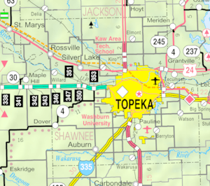
The city of Auburn covers about 0.64 square miles (1.66 square kilometers) of land. It is located in Shawnee County, Kansas.
Auburn's Climate
The weather in Auburn has hot, humid summers. The winters are usually mild to cool. This type of weather is called a humid subtropical climate.
Population Information
| Historical population | |||
|---|---|---|---|
| Census | Pop. | %± | |
| 1880 | 100 | — | |
| 1970 | 261 | — | |
| 1980 | 890 | 241.0% | |
| 1990 | 908 | 2.0% | |
| 2000 | 1,121 | 23.5% | |
| 2010 | 1,227 | 9.5% | |
| 2020 | 1,273 | 3.7% | |
| U.S. Decennial Census | |||
Auburn is part of the larger Topeka Metropolitan Statistical Area. This means it is connected to the economy and community of Topeka.
Population in 2020
The 2020 United States census counted 1,273 people living in Auburn. There were 483 households and 331 families. The population density was about 1,829 people per square mile.
Most residents, about 89%, were white. About 1.5% were Black, and 0.55% were Native American. About 4.8% of the population identified as Hispanic or Latino.
About 31% of the people were under 18 years old. The average age in Auburn was 34.5 years.
Education
The public schools in Auburn are part of the Auburn–Washburn USD 437 school district.
Transportation
Auburn is less than a mile northwest of the Kansas Turnpike. However, the closest exit to the turnpike is in Topeka, which is northeast of Auburn.
Notable person
- Nina E. Allender, an artist and activist for women's right to vote.
See also
 In Spanish: Auburn (Kansas) para niños
 | Ernest Everett Just |
 | Mary Jackson |
 | Emmett Chappelle |
 | Marie Maynard Daly |

