
Auchencloigh Castle facts for kids
Quick facts for kids Auchencloigh Castle |
|
|---|---|
| Auchencloigh, East Ayrshire, Scotland UK |
|
_-_geograph.org.uk_-_398532.jpg)
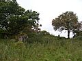
Site of Auchencloigh Castle
|
|

Auchencloigh Castle
|
|
| Coordinates | 55°25′15″N 4°22′49″W / 55.4207°N 4.3803°W |
| Site information | |
| Controlled by | Craufurd clan |
| Open to the public |
No |
| Condition | whin and lime mortar remains |
| Site history | |
| Built | 15th century |
| In use | Until early 18th century |
| Materials | Stone |
Auchencloigh Castle or Auchincloigh Castle is a ruined old building near the Burnton Burn in East Ayrshire, Scotland. It was once part of the lands belonging to the Craufurd clan. This castle played a role in the local history of the Ochiltree area.
Contents
Auchencloigh Castle: A Look at the Ruins
We don't have many old pictures or detailed descriptions of Auchencloigh Castle. The castle sits on a small hill. In 1978, some of its stone walls were still standing. They were about 0.6 to 1.6 meters high and quite thick in places. The walls formed a rectangle, and inside, there seemed to be several small rooms.
Auchencloigh Castle might have been one of several small forts. These forts could have formed a defensive line in the area. Other castles like Drongan and Martnaham might have been part of this chain.
The remains of this medieval tower are made of whinstone. They were put together using lime mortar. The ruins are about 100 meters east of Auchencloigh Farm. We haven't found exact dates for when it was built. However, the thick walls suggest it is very old. One expert thinks it might have been built in the 15th century.
Auchencloigh Farm was located nearby, surrounded by some woods. The castle site is now protected under the Ancient Monuments and Archaeological Areas Act 1979. This means it's an important historical site.
In 1579, a person named William Wallace of Auchincloych was a witness to an important document. This document was about land ownership. In 1578, William and James Cuninghame of Polquharne gave some land to John Cuninghame. This land was called Burntoun and was close to, or included, Auchencloigh.
How Old Maps Show Auchencloigh Castle
Old maps can tell us a lot about how Auchencloigh Castle changed over time.
- Robert Gordon's map (around 1635–1652): This map shows a castle called E. Achincloich. It was located east of Belston Loch.
- Blaeu map (around 1654): This map was made from Timothy Pont's map (around 1600). It shows an intact East Achincloich Castle. It looked smaller than the nearby Kerse Castle. The castle had wooded grounds and was surrounded by water on three sides. A loch called Drumsmodda, now Belston Loch, was to the west. The map also shows a dwelling called West Achincloich.
- Moll's map (1745): This map shows a building at Achincloich, east of a small loch. But it doesn't show a castle.
- Roy's map (1747): This map also records Achincloich, but not as a castle.
- Armstrong's map (1775): This map clearly shows Auchencloigh Castle as a ruin.
- Later maps (1820s): By 1821 and 1820, maps like Thomson's also show Auchencloigh as castle ruins.
These maps help us understand that the castle was standing in the 17th century. By the mid-18th century, it had become a ruin.
Auchencloigh: Local History and Name Meaning
The area around the castle and old farm was once a large opencast mine. This means coal or other materials were dug from the surface. However, the land has now been restored and is used for farming again.
The name 'Auchencloigh' comes from an old language called Gaelic. In Gaelic, achadh means 'field' and cloiche means 'stone'. So, Auchencloigh means 'field of stone'. You can find similar place names in other parts of Scotland. There is even a small village called Auchencloigh in the parish of Sorn. Auchencloigh Lodge is a house near the entrance to the old farm.
There is also an old road nearby. It's a 17th-century type of holloway, which is a sunken path. This path follows what might have been a Roman road. It runs as far as Auchencloigh, near Old Polquhairn. This road is shown on Armstrong's map from 1775. It had a strong cobbled bottom with clay on top.
Images for kids
-
Ruins at Auchencloigh

See Also
