Avalon, Pennsylvania facts for kids
Quick facts for kids
Avalon, Pennsylvania
|
|
|---|---|
|
Borough
|
|

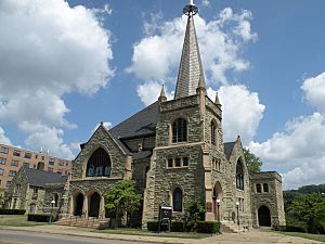
Greenstone United Methodist Church located at 939 California Avenue
|
|
| Etymology: Mythical island in legend of King Arthur | |

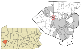
Location in Allegheny County and the U.S. state of Pennsylvania
|
|
| Country | United States |
| State | Pennsylvania |
| County | Allegheny |
| Settled | c. 1800 |
| Incorporated | April 7, 1875 |
| Area | |
| • Total | 0.69 sq mi (1.79 km2) |
| • Land | 0.62 sq mi (1.60 km2) |
| • Water | 0.07 sq mi (0.19 km2) |
| Elevation | 932 ft (284 m) |
| Population
(2020)
|
|
| • Total | 4,762 |
| • Density | 7,717.99/sq mi (2,981.47/km2) |
| Time zone | UTC-5 (EST) |
| • Summer (DST) | UTC-4 (EDT) |
| ZIP code |
15202
|
| Area code(s) | 412 |
| FIPS code | 42-03608 |
| School District | Northgate |
| Website | http://www.boroughofavalon.org/ |
Avalon is a small town, called a borough, in Allegheny County, Pennsylvania, United States. It is located along the Ohio River, about 6 miles (10 km) from Pittsburgh. In 2020, about 4,762 people lived there. Avalon is a residential area, meaning many people live in homes there, and it's part of the larger Pittsburgh area.
Contents
History of Avalon
Avalon became a borough on April 7, 1875. Before that, it was part of a bigger area called Kilbuck Township. A group of 29 property owners wanted their own town. They asked the court to make Avalon a separate borough.
They held an election on December 26, 1874. James Semple was chosen as the first "burgess." A burgess is like a mayor for a borough. The court approved their request, and Avalon officially became a borough.
The name "Avalon" comes from a famous island in the legends of King Arthur. This mythical island was known as the "land of apples." Avalon, Pennsylvania, was named this because it used to have many apple orchards.
Around 1900, streetcars started serving Avalon. These were like electric buses that ran on tracks. They made it easier for people to travel around the borough and to other towns. Streetcar service ended in 1966.
Geography of Avalon
Avalon is located at coordinates 40°30′4″N 80°4′7″W.
The borough covers a total area of about 0.7 square miles (1.8 square kilometers). Most of this is land, with a small part being water. The average height of Avalon is 932 feet (284 meters) above sea level.
Neighboring Communities
Avalon shares its borders with a few other towns:
- To the north, it borders Ben Avon Heights and Kilbuck Township.
- To the east, it borders Bellevue.
- To the west, it borders Ben Avon.
Across the Ohio River to the south, Avalon is near Neville Township and the Davis Island Lock and Dam Site.
Population Changes in Avalon
| Historical population | |||
|---|---|---|---|
| Census | Pop. | %± | |
| 1880 | 326 | — | |
| 1890 | 804 | 146.6% | |
| 1900 | 2,130 | 164.9% | |
| 1910 | 4,317 | 102.7% | |
| 1920 | 5,277 | 22.2% | |
| 1930 | 5,940 | 12.6% | |
| 1940 | 6,155 | 3.6% | |
| 1950 | 6,463 | 5.0% | |
| 1960 | 6,859 | 6.1% | |
| 1970 | 7,010 | 2.2% | |
| 1980 | 6,240 | −11.0% | |
| 1990 | 5,784 | −7.3% | |
| 2000 | 5,294 | −8.5% | |
| 2010 | 4,705 | −11.1% | |
| 2020 | 4,762 | 1.2% | |
| Sources: | |||
Avalon's population has changed over the years. In 1880, only 326 people lived there. By 1900, the population grew to 2,130. It kept growing and reached its highest point in 1970 with 7,010 people. Since then, the population has slowly decreased. In 2020, there were 4,762 residents.
In 2000, there were 5,294 people living in Avalon. About 18% of the population was under 18 years old. About 23.5% of residents were 65 years or older. The average age in Avalon was 41 years.
Education
Students in Avalon attend schools within the Northgate School District.
Notable People
Some well-known people have connections to Avalon:
- Robert J. Corbett: A U.S. Representative who served Pennsylvania.
- Jim Haslett: A former NFL football player and coach.
- Mercury Morris: A Super Bowl-winning running back and kick returner in professional football.
See Also
 In Spanish: Avalon (Pensilvania) para niños
 | Bayard Rustin |
 | Jeannette Carter |
 | Jeremiah A. Brown |

