
Avonside facts for kids
Quick facts for kids
Avonside
|
|
|---|---|
|
Suburb
|
|

Sullivan Park in Avonside
|
|

Avonside
Location in New Zealand
|
|
| Country | New Zealand |
| Local authority | Christchurch |
| Electoral ward |
|
| Area | |
| • Land | 81 ha (200 acre) |
| Population
(June 2023)
|
|
| • Total | 1,670 |
|
|
||
Avonside is a suburb located in the eastern part of Christchurch, New Zealand. It is one of the oldest areas in the city. Only Heathcote is older than Avonside. The Avon River flows right through this suburb.
Contents
History of Avonside

Avonside got its name from the Holy Trinity Avonside church. This church was built next to the Avon River in 1855. A famous architect named Benjamin Mountfort designed part of the church in 1874. He is also buried in the churchyard.
The church was damaged during the 2010 Canterbury earthquake. While it was being fixed, it was hit again by the big 2011 Christchurch earthquake in February. This damage was too severe, so the church had to be taken down later that year.
Avonside was also home to Avonside Girls' High School for many years.
Early Days of Avonside
The original area of the Avonside church parish was set in 1859. It covered a very large part of what is now northeast Christchurch. This included suburbs like Aranui, Burwood, Linwood, and New Brighton. The area stretched all the way to the Styx River.
The land in Avonside is on the flood plain of the Avon River. This means it has very rich soil. However, in the early days of Christchurch, this area was very swampy. It was quite hard to travel across because of the wet ground.
Earthquakes and Their Impact

Avonside was greatly affected by the earthquakes that hit Christchurch. The first big one was on 4 September 2010. During this earthquake, Avonside experienced a lot of liquefaction. This is when the ground acts like a liquid because of shaking. Streets like Keller Street and Retreat Road were covered in water and grey silt. Roads and buildings on Avonside Drive were also cracked. Many homes lost power and water for days. The sewer system was also badly damaged.
The February 2011 Earthquake
A more powerful earthquake hit on 22 February 2011. This one caused even more damage to Avonside. There was more liquefaction and flooding. Roads were damaged, and many houses were severely affected. Some homes lost power for two to three weeks. Most sewer systems needed to be fixed or replaced.
Many groups helped the residents clean up. The New Zealand Army and volunteers like the Student Volunteer Army helped remove huge piles of silt from properties. Local leaders also held meetings to give residents important information.
Aftershocks and Recovery
Another strong aftershock happened in June 2011. This caused more liquefaction and damage. Later that month, the New Zealand Government made a big announcement. Many homes in Avonside were placed in the "Red Zone." This meant the land was too damaged to rebuild on soon. These houses would be bought by the government and taken down. Residents had until April 2013 to move out.
Other parts of Avonside were in the "Green Zone." In these areas, insurance companies could start repairing or rebuilding homes. Some properties were in an "Orange Zone" while the government decided if the land could be fixed. All these decisions have now been made.
Avonside Population
Avonside covers about 0.81 square kilometers (0.31 square miles). As of 2023, it has an estimated population of 1,670 people.
Who Lives in Avonside?
In 2018, Avonside had 1,671 people living there. This was a small decrease from 2013. There were slightly more males than females. The average age of people in Avonside was about 36.5 years old. About 19% of the people were under 15 years old.
Most people in Avonside are of European background (77.4%). There are also many Māori (19.4%), Pasifika (8.1%), and Asian (7.0%) residents. About 18% of the people living in Avonside were born outside New Zealand.
Education in Avonside
Avonside Girls' High School first opened in Avonside in 1919. However, the school's buildings were damaged in the 2011 earthquake. Because of this, the school moved to North New Brighton in 2019.
Images for kids
-
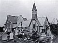
Holy Trinity Avonside Church in 1905
-
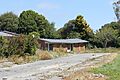
Houses in Bowie Place before they were taken down in 2014
