Aztec Pass facts for kids
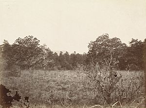
Aztec Pass is a natural opening or low point between mountains in Yavapai County, Arizona. It sits between the Juniper Mountains and the Santa Maria Mountains. A pass like this makes it easier to travel through tough mountain areas.
The highest point of Aztec Pass is about 6,232 feet (1,900 meters) above sea level. This spot is a divide, meaning water flows in different directions from here. To the west, water goes into Muddy Wash, and to the east, it flows into Walnut Creek. These are both important waterways in the area.
The eastern entrance to the pass is at a lower elevation, around 4,583 feet (1,397 meters). This is where Walnut Creek comes out of the hills. The western entrance is at the start of the Muddy Wash valley, near the Juniper Mountains.
A Historic Route Through the Mountains
Aztec Pass has a rich history, especially during the 1800s. It became a very important travel route for pioneers and settlers. This pass was part of a major wagon road that connected different parts of Arizona.
The Hardyville - Prescott Road
In 1864, a man named William Harrison Hardy built a special road through Aztec Pass. This road was called the Hardyville - Prescott Road. It was a toll road, which means people had to pay a fee to use it.
The road connected Hardyville, a steamboat landing on the Colorado River, to Prescott. Prescott was the capital city of the Arizona Territory back then. The road helped people travel and move goods between these two important places.
Key Stops Along the Way
Along the Hardyville - Prescott Road, there were a few notable spots:
- Oaks and Willows: This was a campground located at the western entrance of the pass, near Muddy Wash. Travelers could rest here after a long journey.
- Old Toll Gate: Near the eastern entrance of the pass, there was a toll gate where travelers paid their fees. This gate was moved a few times as the road was improved.
- Camp Hualpai: A military camp called Camp Hualpai was built close to the second toll gate. It was located along Walnut Creek, where the road entered the pass from the south.
Aztec Pass played a big role in the early development of Arizona. It helped connect communities and allowed people to explore and settle new areas.


