
Babbacombe Bay facts for kids

.jpg)

Babbacombe Bay is a beautiful part of the coastline in South-East Devon, England. It is a wide, shallow bay that connects to the larger Lyme Bay. Lyme Bay is known for being the western end of the famous Jurassic Coast, which is mostly in Dorset.
Babbacombe Bay faces east towards the English Channel. This means it is somewhat protected from big tides coming from the east. It is much more protected from the strong tides, currents, and storms that come from the Atlantic Ocean in the west. The bay stretches for about 4.5 miles (7.2 kilometers).
The edges of Babbacombe Bay are:
- To the south, you'll find Hope's Nose. This is the eastern end of the rocky northern edge of Torquay.
- To the north, the bay reaches the River Teign near Teignmouth. There's a short harbor wall there that extends into the east.
Interesting Discoveries
Babbacombe Bay is known for some cool discoveries. For example, tiny pieces of crystalline gold have been found at the southern tip of the bay, near Hope's Nose. These special gold samples are so important that some are displayed at the Natural History Museum, London. They are very interesting to people who collect minerals.
The Dawlish Railway
The town of Dawlish is located along Babbacombe Bay. It has a main railway line that runs right by the sea. This railway was badly damaged during the very strong 2013–14 United Kingdom winter floods. However, it was rebuilt very quickly, showing how important it is to the area.
The Bay's Unique Colors
The sand on the beaches and the cliffs around Babbacombe Bay often have a reddish-brown color. This is because of the type of rock found here. In the 1800s, geologists (scientists who study rocks and the Earth) called the Devonian period the "Old Red Age." This name came from the red and brown rocks, like the Old Red Sandstone, where some of the earliest fossils were discovered.
The Devonian period is also sometimes called the "Age of the Fishes." This is because many different types of fish evolved and became common during that time.
Images for kids
-
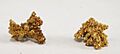
Two crystalline gold specimens from Hope's Nose. The largest is 0.9 x 0.8 x 0.7 cm.

