
Babcock Street station facts for kids
Quick facts for kids
Babcock Street
|
|||||||||||||
|---|---|---|---|---|---|---|---|---|---|---|---|---|---|

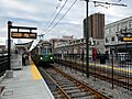
An inbound train at Babcock Street station in December 2021
|
|||||||||||||
| Location | Commonwealth Avenue at Babcock Street Boston, Massachusetts, US |
||||||||||||
| Coordinates | 42°21′06″N 71°07′12″W / 42.3516°N 71.1199°W | ||||||||||||
| Platforms | 2 side platforms | ||||||||||||
| Tracks | 2 | ||||||||||||
| Connections | |||||||||||||
| History | |||||||||||||
| Opened | May 18, 1896 | ||||||||||||
| Rebuilt | 1970s; November 15, 2021 | ||||||||||||
| Traffic | |||||||||||||
| Passengers (2011) | Weekday average boardings: Babcock Street: 1,387 Pleasant Street: 1,167 |
||||||||||||
| Services | |||||||||||||
|
|||||||||||||
|
|||||||||||||
Babcock Street station is a train stop in Boston, Massachusetts. It's part of the Massachusetts Bay Transportation Authority (MBTA) Green Line's B branch. You can find it right in the middle of Commonwealth Avenue, near the Boston University campus.
The station is easy to use for everyone, with two platforms for trains going in different directions. You can get to the platforms from Babcock Street and Pleasant Street. Streetcar service started here in 1896. Over time, different companies ran the line. In the 1960s, it became the Green Line B branch. The old stops at Alcorn Street and Pleasant Street were combined into the new Babcock Street station. Construction for this new station began in February 2021, and it opened on November 15, 2021.
Contents
What the Station Looks Like
Babcock Street station is in the middle of Commonwealth Avenue. It's located between Harry Agganis Way and Babcock Street. This area is next to the West Campus of Boston University.
The station has two platforms, one for each direction of the train tracks. These platforms are about 225 feet long. They are designed to be easy for everyone to use, including people with disabilities. You can walk from the platforms to both Babcock Street and Harry Agganis Way. Each platform has a long roof, called a canopy, which is about 150 feet long. These canopies have colorful, wavy panels on their sides.
Station History
Early Streetcar Service

In the mid-1890s, the West End Street Railway built new tracks for streetcars. These tracks were in the middle of Commonwealth Avenue. Service on these new tracks began on May 18, 1896. This route was later extended. On November 8, 1897, the streetcars started using the Tremont Street subway.
The Boston Elevated Railway (BERy) took over the West End Street Railway in 1897. They continued to expand the train system. In 1900, new tracks opened on Commonwealth Avenue. This allowed direct service from Lake Street (now Boston College station) to downtown Boston. Later, in 1912, the line was extended to Watertown Yard. This created the main route that was used for many years.
When the new Braves Field opened in 1915, a special loop track was built near Babcock Street. This loop allowed streetcars to easily serve the ballpark. It was also used to turn trains around for Red Sox games. The loop was very busy during games. For example, during the 1948 World Series, streetcars ran very often.
Boston University bought Braves Field in 1953. They wanted to use the land where the loop was. So, the loop track was removed on January 15, 1962.
The Metropolitan Transit Authority (MTA) took over from the BERy in 1947. Then, the Massachusetts Bay Transportation Authority (MBTA) took over from the MTA in 1964. In 1965, the MBTA named the streetcar lines the Green Line. By 1967, the Watertown line became the Green Line A branch, and the Boston College line became the B branch. The A branch service ended in 1969, leaving only the B branch on Commonwealth Avenue. Around 1975, the Alcorn Street stop was moved to Babcock Street.
Combining Stations

In 2014, the MBTA started planning to combine some stops near Boston University. These stops included Boston University West, St. Paul Street, Pleasant Street, and Babcock Street. These four stops were not easy for everyone to use. The plan was to turn them into two new, fully accessible stops. Pleasant Street and Babcock Street stations would be combined into one new station.
The MBTA gave out a construction contract in March 2020. Work began in February 2021 and was expected to finish in early 2022. During construction, buses sometimes replaced train service. In February 2021, the MBTA announced the new combined stop would be called Babcock Street. Pleasant Street station closed permanently on February 26, 2021, so construction could start.
On July 30, 2021, two trains had an accident near the station while it was being built. The old Babcock Street station closed on November 12, 2021. After a weekend closure, the new Babcock Street station opened on November 15, 2021. The old station was then removed.
Images for kids
-
An inbound train at Babcock Street station in December 2021
See also
 In Spanish: Calle Babcock (Metro de Boston) para niños
