Baglung District facts for kids
Quick facts for kids
Baglung
बागलुङ जिल्ला
|
|
|---|---|

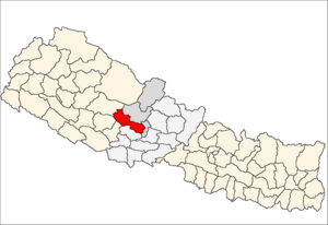
Baglung is located in the south of Dhawalagiri Zone
|
|
| Country | Nepal |
| Region | {{{region}}} |
| Headquarters | Baglung |
| Area | |
| • Total | 1,784 km2 (689 sq mi) |
| Population
(2011)
|
|
| • Total | 268,613 |
| • Density | 150.57/km2 (389.97/sq mi) |
| Time zone | UTC+5:45 (NPT) |
| Main language(s) | Nepali |
| Website | Official Website: http://daobaglung.moha.gov.np |
Baglung District (Nepali: बागलुङ जिल्ला) is a special part of Nepal, like a county or region. It's located in the Dhawalagiri Zone, which is a larger area. The main town and administrative center of the district is also called Baglung.
Baglung District covers an area of about 1,784 square kilometers. Imagine a square with sides of about 42 kilometers – that's roughly how big it is! In 2011, about 268,613 people lived there.
Contents
What is Baglung District?
Baglung District is one of the many districts that make up the country of Nepal. Districts are important for local government and for organizing services for the people who live there. Each district has its own unique features, from its landscapes to its culture.
Where is Baglung Located?
Baglung District is found in the western part of Nepal. It's part of the Gandaki Pradesh province, which is one of Nepal's seven provinces. Its location means it has a mix of different geographical features, from river valleys to hills.
The Land and Nature of Baglung
The district's landscape is mostly hilly, with some lower mountain ranges. Rivers flow through the valleys, creating beautiful scenery and providing water for farming. The varied terrain means you can find different types of plants and animals here. The natural beauty makes it a great place for people who love the outdoors.
Rivers and Valleys
Many rivers cross through Baglung District. These rivers are important for the people living there, providing water for daily life and for growing crops. The valleys formed by these rivers are often where towns and villages are located, as the land is flatter and more suitable for building and farming.
Who Lives in Baglung?
The people of Baglung District are mostly Nepali speakers, but you might hear other local languages too. The population is a mix of different ethnic groups, each with their own traditions and customs. This creates a rich and diverse culture within the district.
Culture and Traditions
Like much of Nepal, Baglung District has a vibrant culture. Festivals are celebrated throughout the year, often with music, dancing, and special foods. These traditions are passed down through generations and help keep the community strong. People often wear traditional clothing during special events.
What Do People Do in Baglung?
Many people in Baglung District work in agriculture, which means they grow crops or raise animals. The fertile valleys are good for farming. Tourism is also becoming more important, as visitors come to see the natural beauty and experience the local culture.
Farming and Local Economy
Farming is a major part of the economy in Baglung. Farmers grow crops like rice, maize, and various vegetables. They also raise livestock. Local markets are important places where people buy and sell goods, supporting the community's economy.
Tourism and Attractions
Baglung District offers several attractions for visitors. Its natural beauty, including rivers and hills, is a big draw. There are also cultural sites like temples and monasteries. Some people enjoy trekking or exploring the local villages to experience the authentic Nepali way of life.
How is Baglung Governed?
The district headquarters, also named Baglung, is the main center for local government and administration. This is where important decisions are made for the district, and where services like schools and health centers are managed. The district administration works to improve the lives of the people in Baglung.
Related pages
 | Kyle Baker |
 | Joseph Yoakum |
 | Laura Wheeler Waring |
 | Henry Ossawa Tanner |

