
Dhawalagiri Zone facts for kids
Quick facts for kids
Dhaulagiri Zone
धौलागिरी अञ्चल
|
|
|---|---|

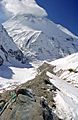
Dhaulagiri Mountain Range
|
|

Dhaulagiri Zone
|
|
| Country | |
| Area | |
| • Total | 8,148 km2 (3,146 sq mi) |
| Population
(2001)
|
|
| • Total | 556,191 |
| • Density | 68.261/km2 (176.795/sq mi) |
| Time zone | UTC+5:45 (Nepal Time) |
Dhawalagiri (Nepali: धौलागिरी अञ्चल) was one of the fourteen administrative zones of Nepal. It was located in the western part of the country. In 2001, about 556,191 people lived there.
This zone was named after the huge Dhaulagiri mountain range. It was a beautiful area with different types of land, from hills to high mountains.
Districts of Dhawalagiri Zone
The Dhawalagiri Zone was made up of four smaller areas called districts. Each district had its own main town, which was like its capital.
| District Name | Type of Land | Main Town |
|---|---|---|
| Baglung | Hilly | Baglung |
| Mustang | Mountainous | Jomsom |
| Myagdi | Hilly | Beni |
| Parbat | Hilly | Kusma |
More About Nepal's Zones
If you want to learn more about how Nepal is divided, check out these pages:
You can also find out more about the western regions of Nepal and the Dhawalagiri Zone's location:
- Introduction of Western regions of Nepal.
- About Dhawalagiri Zone and its locations.
Images for kids
-
Dhaulagiri Mountain Range
See also
 In Spanish: Zona de Dhaulagiri para niños

All content from Kiddle encyclopedia articles (including the article images and facts) can be freely used under Attribution-ShareAlike license, unless stated otherwise. Cite this article:
Dhawalagiri Zone Facts for Kids. Kiddle Encyclopedia.