Bair Island facts for kids
Quick facts for kids Bair Island State Marine Park |
|
|---|---|
|
IUCN Category V (Protected Landscape/Seascape)
|
|

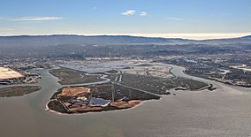
Bair Island in 2018
|
|
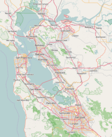
| Location | San Francisco Bay |
| Nearest city | Redwood City, California |
| Area | 3,398 acres (13.75 km2) |
| Established | 1986 |
| Governing body | US Fish and Wildlife Service, Don Edwards San Francisco Bay National Wildlife Refuge |
Bair Island is a special marsh area in Redwood City, California. A marsh is a type of wetland with grassy plants and shallow water. This area covers about 3,000 acres and includes three smaller islands: Inner, Middle, and Outer islands. Bair Island is part of a bigger protected area called the Don Edwards San Francisco Bay National Wildlife Refuge.
The island is surrounded by water channels. To the northwest is the Steinberger Slough, which is a narrow water channel. To the southeast is Redwood Creek. The California Department of Fish and Wildlife also manages a part of Bair Island, called the Bair Island Ecological Reserve. This reserve covers about 1,985 acres on the Middle and Outer islands.
Bair Island is a very important habitat for many animals. It is home to endangered species like the California clapper rail (a type of bird) and the Salt marsh harvest mouse. Many birds also stop here during their long journeys along the Pacific Flyway. This is a major route for birds migrating across North America. A channel called Corkscrew Slough cuts through Bair Island. It is a favorite spot for harbor seals to rest out of the water.
Contents
A Look at Bair Island's Past
Bair Island is the biggest undeveloped island in the San Francisco Bay. For a long time, since the 1800s, people used the island for farming, raising animals, and making salt.
Saving Bair Island from Development
In the 1980s, there was a plan to build a huge neighborhood called South Shores on the marshland. This plan included about 4,000 houses. The local city council in Redwood City approved the idea. However, many citizens were against it. They held a special vote called a referendum. In 1982, the citizens narrowly voted against the project by just 44 votes. This meant the housing plan could not go forward.
Becoming a Protected Area
In 1996, a group called the Peninsula Open Space Trust bought Bair Island. They then gave the land to the Don Edwards National Wildlife Refuge. This made Bair Island a protected area. The Bair Island Ecological Reserve was officially created in 1997.
New Ways to Explore the Island
In 2013, a new bridge for walkers was opened. This bridge connects to trails around the island. It allows people to visit and see the wetlands that have been brought back to their natural state. Since 2017, tour guides have been leading walks on these trails. They show visitors how the wetland restoration has helped the area. Some animals and plants that have grown well since the restoration include the California Ridgway's rail (another bird), pickleweed (a type of plant), and pelicans.
See also


