Baratier facts for kids
Quick facts for kids
Baratier
|
||
|---|---|---|
 |
||
|
||
| Country | France | |
| Region | Provence-Alpes-Côte d'Azur | |
| Department | Hautes-Alpes | |
| Arrondissement | Gap | |
| Canton | Embrun | |
| Intercommunality | Serre-Ponçon | |
| Area
1
|
15.99 km2 (6.17 sq mi) | |
| Population
(Jan. 2019)
|
620 | |
| • Density | 38.8/km2 (100.4/sq mi) | |
| Time zone | UTC+01:00 (CET) | |
| • Summer (DST) | UTC+02:00 (CEST) | |
| INSEE/Postal code |
05012 /05200
|
|
| Elevation | 780–2,857 m (2,559–9,373 ft) (avg. 858 m or 2,815 ft) |
|
| 1 French Land Register data, which excludes lakes, ponds, glaciers > 1 km2 (0.386 sq mi or 247 acres) and river estuaries. | ||
Baratier is a small and charming town (also called a commune) located in the Hautes-Alpes department in southeastern France. It is a place where people live and work, surrounded by beautiful natural scenery.
Contents
What is Baratier Like?
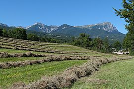
Baratier is nestled in the Southern Alps, a famous mountain range. The town is known for its lovely landscapes, including green plains and tall mountains. It's a peaceful area, perfect for enjoying nature.
Geography and Location
Baratier is part of the Hautes-Alpes department. This area is in the Provence-Alpes-Côte d'Azur region of France. The town sits at an elevation of about 858 meters (2,815 feet) above sea level. The highest point in the commune is 2,857 meters (9,373 feet). The lowest point is 780 meters (2,559 feet).
Nearby Towns and Features
Baratier is close to the town of Embrun. It is also near the Durance River and the large Serre-Ponçon Lake. These natural features make the area very scenic.
How Many People Live in Baratier?
The number of people living in Baratier changes over time. This is called the population. Knowing the population helps us understand how big a town is.
Population Changes Over Time
The population of Baratier has been recorded for many years. In January 2019, about 620 people lived there. The population has grown a bit over the past few years.
| Historical population | ||
|---|---|---|
| Year | Pop. | ±% |
| 2005 | 519 | — |
| 2006 | 517 | −0.4% |
| 2007 | 512 | −1.0% |
| 2008 | 511 | −0.2% |
| 2009 | 511 | +0.0% |
| 2010 | 510 | −0.2% |
| 2011 | 503 | −1.4% |
| 2012 | 499 | −0.8% |
| 2013 | 520 | +4.2% |
| 2014 | 539 | +3.7% |
| 2015 | 559 | +3.7% |
| 2016 | 593 | +6.1% |
Getting Around Baratier
Roads are important for people to travel in and out of Baratier. They connect the town to other places.
Main Roads
Several roads pass through Baratier. These include the D40, D40A, D240, D994H, and N94. These roads help people get to nearby towns and cities. They are used for cars, trucks, and other vehicles.
What Do the Road Names Mean?
- D roads (like D40) are departmental roads. They are managed by the local department.
- N roads (like N94) are national roads. They are managed by the national government.
See also
 In Spanish: Baratier para niños
 | Janet Taylor Pickett |
 | Synthia Saint James |
 | Howardena Pindell |
 | Faith Ringgold |


