Barcillonnette facts for kids
Quick facts for kids
Barcillonnette
|
||
|---|---|---|
 |
||
|
||
| Country | France | |
| Region | Provence-Alpes-Côte d'Azur | |
| Department | Hautes-Alpes | |
| Arrondissement | Gap | |
| Canton | Tallard | |
| Intercommunality | Tallard–Barcillonnette | |
| Area
1
|
19.51 km2 (7.53 sq mi) | |
| Population
(Jan. 2019)
|
127 | |
| • Density | 6.509/km2 (16.86/sq mi) | |
| Time zone | UTC+01:00 (CET) | |
| • Summer (DST) | UTC+02:00 (CEST) | |
| INSEE/Postal code |
05013 /05110
|
|
| Elevation | 691–1,560 m (2,267–5,118 ft) (avg. 830 m or 2,720 ft) |
|
| 1 French Land Register data, which excludes lakes, ponds, glaciers > 1 km2 (0.386 sq mi or 247 acres) and river estuaries. | ||
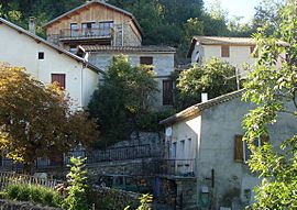
Barcillonnette is a small commune in the Hautes-Alpes department in southeastern France. A commune is like a small town or village. It is known for its quiet, rural setting.
Contents
How Many People Live Here?
Barcillonnette is a very small village. The number of people living here has changed over the years. In 2019, about 127 people lived in Barcillonnette.
| Historical population | ||
|---|---|---|
| Year | Pop. | ±% |
| 1962 | 75 | — |
| 1968 | 88 | +17.3% |
| 1975 | 88 | +0.0% |
| 1982 | 83 | −5.7% |
| 1990 | 102 | +22.9% |
| 1999 | 104 | +2.0% |
| 2008 | 126 | +21.2% |
Getting Around Barcillonnette
Barcillonnette is connected by a few roads. These roads help people travel to and from the village.
Local Roads
The D20 and D420 roads pass through Barcillonnette. These are local roads that connect the commune to nearby areas.
Main Highways
The A51 autoroute is a major highway. It goes around Barcillonnette, so it does not pass directly through the village. This highway helps people travel faster to bigger cities.
See Also
 In Spanish: Barcillonnette para niños
 | Audre Lorde |
 | John Berry Meachum |
 | Ferdinand Lee Barnett |


