Barlow Island facts for kids

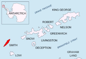
Location of Smith Island in the South Shetland Islands
|
|
|
Location of Smith Island
|
|
| Geography | |
|---|---|
| Location | Antarctica |
| Coordinates | 62°52′04.5″S 62°20′24.2″W / 62.867917°S 62.340056°W |
| Archipelago | South Shetland Islands |
| Area | 5.28 ha (13.0 acres) |
| Length | 0.38 km (0.236 mi) |
| Width | 0.16 km (0.099 mi) |
| Administration | |
| Administered under the Antarctic Treaty System | |
| Demographics | |
| Population | Uninhabited |
Barlow Island is a tiny island located near Smith Island in Antarctica. It's a small piece of land that isn't covered by ice.
The island is about 380 meters (1,247 feet) long and 160 meters (525 feet) wide. Its total area is around 5.28 hectares (13 acres). No one lives on Barlow Island.
The island was named after a British scientist named Peter Barlow. He was a physicist and mathematician who lived from 1776 to 1862. The name was first used in 1829 by a British naval group led by Captain Henry Foster. They originally called a different spot on Smith Island "Cape Barlow."
Where is Barlow Island Located?
Barlow Island is found in the South Shetland Islands, which are a group of islands off the coast of Antarctica.
It is located at these coordinates: 62°52′04.5″S 62°20′24.2″W.
Here's how far it is from other places nearby:
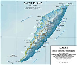
- 2.14 kilometers (1.33 miles) west-northwest of Cape Smith.
- 1.06 kilometers (0.66 miles) west-northwest of Alfeus Island.
- 2.42 kilometers (1.50 miles) north-northeast of Matochina Peak.
- 2.48 kilometers (1.54 miles) northeast of Delyan Point.
- 11.33 kilometers (7.04 miles) northeast of Gregory Point.
Different countries like Britain, Chile, Argentina, and Bulgaria have mapped this area over the years.


