Alfeus Island facts for kids

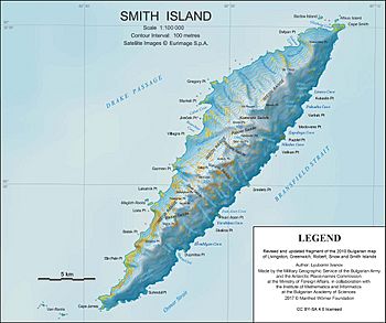
Topographic map of Smith Island
|
|
| Geography | |
|---|---|
| Location | Antarctica |
| Coordinates | 62°52′12.4″S 62°18′53″W / 62.870111°S 62.31472°W |
| Archipelago | South Shetland Islands |
| Length | 310 m (1,020 ft) |
| Width | 120 m (390 ft) |
| Administration | |
| Administered under the Antarctic Treaty System | |
| Demographics | |
| Population | uninhabited |
Alfeus Island (which is ostrov Alfeus in Bulgarian) is a small, rocky island located near the continent of Antarctica. It's about 310 meters (1,017 feet) long and 120 meters (394 feet) wide. You can find it just off the northern coast of Smith Island, which is part of the South Shetland Islands.
Where Did the Name Come From?
Alfeus Island got its name from a special ship called the Alfeus. This ship was a large fishing trawler owned by a Bulgarian company. The Alfeus and other ships from Bulgaria, the Soviet Union, Poland, and East Germany were among the first to fish in the waters around Antarctica. They explored areas like South Georgia, the Kerguelen Islands, the South Orkney Islands, the South Shetland Islands, and the Antarctic Peninsula from the 1970s to the early 1990s.
Where Is Alfeus Island Located?
Alfeus Island is found at coordinates 62°52′12.4″S 62°18′53″W / 62.870111°S 62.31472°W. It's about 660 meters (2,165 feet) northwest of a place called Cape Smith. The island is also 3.7 kilometers (2.3 miles) east-northeast of Delyan Point and 1.06 kilometers (0.66 miles) east-southeast of Barlow Island. Bulgarian experts mapped this area in 2018.
Maps of the Area
You can find Alfeus Island on detailed maps of Antarctica. One helpful map is:
- L.L. Ivanov. Antarctica: Livingston Island and Smith Island. This map shows the topography (the shape of the land) at a scale of 1:100,000. It was created by the Manfred Wörner Foundation in 2017 and updated in 2018.


