Barraba, New South Wales facts for kids
Quick facts for kids BarrabaNew South Wales |
|||||||||
|---|---|---|---|---|---|---|---|---|---|

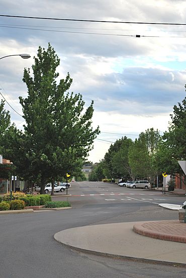
The main street of Barraba
|
|||||||||
| Population | 1,410 (2016 census) | ||||||||
| Established | 1850s | ||||||||
| Postcode(s) | 2347 | ||||||||
| Elevation | 500 m (1,640 ft) | ||||||||
| Location | |||||||||
| LGA(s) | Tamworth Regional Council | ||||||||
| County | Darling | ||||||||
| State electorate(s) | Tamworth | ||||||||
| Federal Division(s) | New England | ||||||||
|
|||||||||
Barraba is a town in the New England region of northern New South Wales, Australia. It's a place where about 1,400 people lived in 2016. Barraba used to be its own local government area, but now it's part of the Tamworth Regional Council. This town is also special because it's part of an important area for birds, especially the regent honeyeater, which is an endangered bird. A railway line used to end here, but it's now closed.
Contents
History of Barraba
The Kamilaroi people were the first to live in the Barraba area. They lived there long before Europeans arrived. In 1827, an explorer named Allan Cunningham was the first European to visit the region. He also found the Manilla River.
Around 1837 or 1838, a large piece of land called Barraba Station was set up. In 1852, a surveyor named J. T. Gorman mapped out where the town would be.
Town Growth and Development
During the 1850s, people found gold nearby. This helped the town of Barraba grow.
- In 1856, the first post office opened. A brick post office was built in 1882.
- A school started in 1861.
- In 1876, land in Barraba was sold at an auction. The first church and bank were also built that year.
- The Commercial Hotel was built in 1878.
- The Barraba Court House was built in 1881.
- Barraba officially became a town on March 20, 1885.
More important buildings were built in the 1890s. These included the hospital in 1891 and the Wesleyan Church in 1898. By 1893, about 500 people lived in Barraba. This number grew to 1,164 by 1921.
A local newspaper, the Barraba Gazette, started in 1900. It stopped printing in 2020. News about Barraba is now in the Manilla Express newspaper. The railway line to Barraba opened in 1908. The last train ran in 1983, and most of the line closed in 1987. In 1933, the Connors Creek dam was built to supply water to the town.
| Historical population | ||
|---|---|---|
| Year | Pop. | ±% |
| 1921 | 1,164 | — |
| 1933 | 1,428 | +22.7% |
| 1947 | 1,461 | +2.3% |
| 1954 | 1,521 | +4.1% |
| 1961 | 1,469 | −3.4% |
| 1966 | 1,425 | −3.0% |
| 1971 | 1,583 | +11.1% |
| 1976 | 1,947 | +23.0% |
| 1981 | 1,679 | −13.8% |
| 1986 | 1,498 | −10.8% |
| 1991 | 1,427 | −4.7% |
| 1996 | 1,267 | −11.2% |
| 2001 | 1,208 | −4.7% |
| 2006 | 1,161 | −3.9% |
| 2011 | 1,150 | −0.9% |
| 2016 | 1,126 | −2.1% |
| 2021 | 1,035 | −8.1% |
| Source: Australian Bureau of Statistics data. | ||
Mining in Barraba
Mining has been an important part of Barraba's history.
Copper Mining
In 1889, copper was found at Gulf Creek, near Barraba. The first copper mine opened there in 1892. A small village grew around the mine. It had a hotel, a school, and a post office. The Gulf Creek Post Office was open from 1897 to 1966. In 1901, the copper mine was one of the biggest in the state. About 300 people lived in the village at that time.
Woodsreef Asbestos Mine
A type of mineral called chrysotile asbestos was mined at Woodsreef, also near Barraba. This mining happened from 1919 until the 1980s. A company called Chrysotile Corporation of Australia mined a lot of asbestos from 1970 to 1983. They dug up huge amounts of rock and produced about 500,000 tonnes of white asbestos.
When the mine closed, it left behind a very large amount of waste rock. This waste covers an area about the size of 117 football fields. There is also a pile of fine waste material, called tailings, which is up to 70 metres high.
People have been worried that the waste from the old mine could be a health risk. In 2008, a TV show called The 7.30 Report talked about these concerns. The Asbestos Diseases Foundation of Australia asked for the site to be cleaned up. They also wanted to stop people from going near it. A public dirt road used to go through the site, but it was closed in 2013.
After the TV report, the government asked for a study on the health effects for the Barraba community. This report was finished, but its findings have not been made public.
In 2011, the New South Wales government gave $6.3 million to clean up the mine site. This money was used to fix the biggest health, safety, and environmental problems. The work included:
- Safely containing the asbestos waste.
- Removing old buildings like the mill and offices.
- Checking the air quality during and after the cleanup.
- Closing the road near the mine.
Climate and Weather
| Climate data for Barraba Post Office | |||||||||||||
|---|---|---|---|---|---|---|---|---|---|---|---|---|---|
| Month | Jan | Feb | Mar | Apr | May | Jun | Jul | Aug | Sep | Oct | Nov | Dec | Year |
| Record high °C (°F) | 41.3 (106.3) |
41.8 (107.2) |
38.2 (100.8) |
34.4 (93.9) |
29.5 (85.1) |
24.4 (75.9) |
23.4 (74.1) |
32.1 (89.8) |
33.4 (92.1) |
36.9 (98.4) |
40.9 (105.6) |
41.1 (106.0) |
41.8 (107.2) |
| Mean daily maximum °C (°F) | 31.7 (89.1) |
30.9 (87.6) |
28.9 (84.0) |
25.0 (77.0) |
20.4 (68.7) |
16.8 (62.2) |
16.0 (60.8) |
17.9 (64.2) |
21.4 (70.5) |
25.0 (77.0) |
27.8 (82.0) |
30.5 (86.9) |
24.4 (75.9) |
| Mean daily minimum °C (°F) | 16.4 (61.5) |
16.1 (61.0) |
12.7 (54.9) |
7.9 (46.2) |
4.3 (39.7) |
1.6 (34.9) |
0.2 (32.4) |
1.1 (34.0) |
4.2 (39.6) |
8.3 (46.9) |
11.8 (53.2) |
14.6 (58.3) |
8.3 (46.9) |
| Record low °C (°F) | 5.8 (42.4) |
5.0 (41.0) |
0.1 (32.2) |
−3.7 (25.3) |
−6.2 (20.8) |
−8.9 (16.0) |
−9.4 (15.1) |
−7.7 (18.1) |
−5.0 (23.0) |
−2.7 (27.1) |
−0.6 (30.9) |
3.4 (38.1) |
−9.4 (15.1) |
| Average precipitation mm (inches) | 87.7 (3.45) |
77.1 (3.04) |
54.1 (2.13) |
39.6 (1.56) |
42.5 (1.67) |
46.7 (1.84) |
43.8 (1.72) |
39.8 (1.57) |
44.2 (1.74) |
64.0 (2.52) |
72.6 (2.86) |
77.4 (3.05) |
688.7 (27.11) |
Barraba has a weather station at the Post Office. It started reporting rain in 1881. In 1966, it became a full weather station, with people taking readings.
Extreme Weather Events
Barraba has experienced some interesting weather events over the years:
- 1898: The first known snowstorm in the town was reported.
- 1907: A hailstorm hit the town in October.
- 1915: A strong thunderstorm caused damage in February. It dropped a lot of rain quickly. Strong winds knocked down trees and damaged buildings.
- 1955: The most rain in one day was recorded in February, with 194.3 mm.
- 1984: The coldest maximum temperature was recorded in July, at 5.8 °C. Another snowstorm also happened that July.
- 2018-2020: The area faced a major drought. This affected farmers and lowered the water levels in the Split Rock Dam.
Water Supply for Barraba
Before a new pipeline was built, Barraba got its water from the Manilla River, Barraba Creek, and Connors Creek Dam. If these sources ran low, the town used emergency underground water pumps.
In 2012, approval was given to build a pipeline from the Split Rock Dam. This dam was built in 1988 and already had a special valve for the pipeline. The pipeline and other related work were finished in December 2015.
Barraba Community Group
The Barraba Community Development Committee is a group that works with the Tamworth Regional Council. This group has talked to local, state, and federal governments about important issues. These include the pipeline from Split Rock Dam and the cleanup of the Woodsreef Mine. They help the community communicate with the Tamworth Regional Council.
Famous People from Barraba
- Bill Bright – a person who made harpsichords (an old musical instrument)
- Clive Crowley – a soldier
- Grace Crowley – an artist
- Shaun Faulkner – won the fourth season of The Mole TV show in 2003
- Rupert Richardson – an artist who helped decorate Bill Bright's harpsichords
- Andrew Farriss – a founding member of the band INXS and a singer/songwriter
See also
 In Spanish: Barraba para niños
 | Kyle Baker |
 | Joseph Yoakum |
 | Laura Wheeler Waring |
 | Henry Ossawa Tanner |


