Barrancabermeja facts for kids
Quick facts for kids
Barrancabermeja
|
|||
|---|---|---|---|
|
Municipality and city
|
|||
 |
|||
|
|||
| Nickname(s):
Oil Capital of Colombia
|
|||

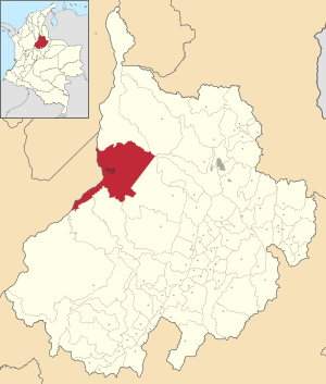
Location of the town and municipality of Barrancabermeja in the Santander Department
|
|||
| Country | |||
| Department | Santander | ||
| Foundation | October 12, 1536 | ||
| Erection as City | April 22, 1922 | ||
| Area | |||
| • Municipality and city | 1,327 km2 (512 sq mi) | ||
| • Urban | 32.4 km2 (12.5 sq mi) | ||
| Elevation | 75 m (246 ft) | ||
| Population
(2018 census)
|
|||
| • Municipality and city | 203,537 | ||
| • Density | 153.38/km2 (397.26/sq mi) | ||
| • Urban | 177,272 | ||
| • Urban density | 5,471/km2 (14,171/sq mi) | ||
| Demonym(s) | Barranqueño (a) | ||
| Climate | Af | ||
| Website | Official website: https://web.archive.org/web/20130817075421/http://www.barrancabermeja.gov.co/alcaldia/ | ||
Barrancabermeja is a city in Colombia. It's located right by the Magdalena River in the western part of the Santander region.
This city is super important because it has the biggest oil refinery in Colombia, run by a company called ECOPETROL. That's why Barrancabermeja is often called the Oil Capital of Colombia!
It's about 114 kilometers (70 miles) west of Bucaramanga, which is the capital city of Santander. Barrancabermeja is the largest city in its area and the second largest in the whole department.
Get ready for warm weather! Barrancabermeja is known for having high temperatures all year. It's one of Colombia's hottest cities. The many rivers and water sources around it also make it very humid.
Contents
History of Barrancabermeja
Barrancabermeja was founded on October 12, 1536. It officially became a city on April 22, 1922.
On February 23, 2022, the city felt a 5.5 magnitude earthquake. This was measured on the Ritcher Scale.
Geography and Location
Barrancabermeja is surrounded by other towns and natural features. To the north, you'll find Puerto Wilches. To the south are Puerto Parra and Simacota. San Vicente de Chucuri and Giron are to the southeast.
The mighty Magdalena River flows to the west of the city. Barrancabermeja is about 116 kilometers (72 miles) from Bucaramanga, the capital of Santander.
The Magdalena River Bridge
The city sits right on the banks of the Magdalena River. In the past, people used a ferry to cross the river between Santander and Antioquia. Now, a big bridge connects these two sides. This makes travel much easier!
Climate and Weather
Barrancabermeja has a tropical monsoon climate. This means it gets a lot of rain almost every month, except for January, which is a bit drier.
| Climate data for Barrancabermeja (Yariguíes Airport), elevation 126 m (413 ft), (1981–2010) | |||||||||||||
|---|---|---|---|---|---|---|---|---|---|---|---|---|---|
| Month | Jan | Feb | Mar | Apr | May | Jun | Jul | Aug | Sep | Oct | Nov | Dec | Year |
| Mean daily maximum °C (°F) | 32.8 (91.0) |
33.1 (91.6) |
32.6 (90.7) |
32.0 (89.6) |
31.8 (89.2) |
32.0 (89.6) |
32.4 (90.3) |
32.4 (90.3) |
31.7 (89.1) |
31.1 (88.0) |
31.2 (88.2) |
31.7 (89.1) |
32.1 (89.7) |
| Daily mean °C (°F) | 28.2 (82.8) |
28.5 (83.3) |
28.2 (82.8) |
27.9 (82.2) |
27.7 (81.9) |
27.7 (81.9) |
27.8 (82.0) |
27.7 (81.9) |
27.3 (81.1) |
27.0 (80.6) |
27.2 (81.0) |
27.6 (81.7) |
27.7 (81.9) |
| Mean daily minimum °C (°F) | 23.6 (74.5) |
23.8 (74.8) |
23.8 (74.8) |
23.7 (74.7) |
23.5 (74.3) |
23.4 (74.1) |
23.2 (73.8) |
23.1 (73.6) |
22.9 (73.2) |
23.0 (73.4) |
23.3 (73.9) |
23.5 (74.3) |
23.4 (74.1) |
| Average precipitation mm (inches) | 51.1 (2.01) |
124.8 (4.91) |
183.1 (7.21) |
299.9 (11.81) |
373.7 (14.71) |
268.1 (10.56) |
229.6 (9.04) |
288.5 (11.36) |
338.4 (13.32) |
408.4 (16.08) |
303.1 (11.93) |
132.0 (5.20) |
3,000.7 (118.14) |
| Average precipitation days | 6.3 | 9.6 | 14.1 | 19.4 | 20.6 | 18.2 | 17.4 | 20.2 | 21.2 | 21.1 | 17.9 | 10.6 | 196.6 |
| Average relative humidity (%) | 73.9 | 73.3 | 76.6 | 81.0 | 81.7 | 80.8 | 78.0 | 78.6 | 80.8 | 82.9 | 83.1 | 79.7 | 79.2 |
| Mean monthly sunshine hours | 222.2 | 178.9 | 154.3 | 146.7 | 165.9 | 175.8 | 210.3 | 205.2 | 181.9 | 168.0 | 167.4 | 189.5 | 2,166.1 |
| Mean daily sunshine hours | 7.2 | 6.3 | 5.0 | 4.9 | 5.4 | 5.9 | 6.8 | 6.6 | 6.1 | 5.4 | 5.6 | 6.1 | 5.9 |
| Source: Instituto de Hidrologia Meteorologia y Estudios Ambientales | |||||||||||||
Culture and Life in Barrancabermeja
The culture in Barrancabermeja is a mix of many different Colombian traditions. This is because many people moved here when the oil industry started to grow.
The city is known for being open and lively. It's a place where different cultures come together.
Music and Dance
When it comes to music, you'll often hear vallenato and other Caribbean rhythms. The nightlife is exciting, with many clubs playing Salsa and merengue music for dancing.
Local Markets and Products
Near the river port, you'll find a busy market area. Motorboats and canoes arrive constantly, bringing fresh fish and farm products. Farmers from along the river bring things like maize (corn), cassava (also called yuca), plantains, and cacao.
Sports and Events
Barrancabermeja has also hosted big sports events. In 1996 and 2000, the city was home to the Mundial de Patinaje, which is an international inline-skating competition.
Transportation
The city is served by Yariguíes Airport. This airport helps people travel to and from Barrancabermeja.
See also
 In Spanish: Barrancabermeja para niños
 | Shirley Ann Jackson |
 | Garett Morgan |
 | J. Ernest Wilkins Jr. |
 | Elijah McCoy |


